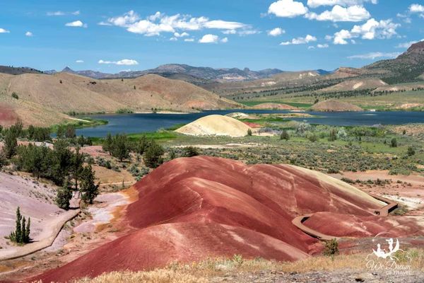
Rainbow Mountains From Titan Carcass Remains?
Quite frankly, the discovery of these rainbow mountains has been breathtaking.
The first question is: why do we see banded rocks and where are the colours coming from? What is the cause? There is a scientific process that seems to explain where the colours are coming from and this will be mentioned in this section. The other important aspect to the preservation of Titan flesh is the presence of saline (salt) water. Simply, I would like to suggest that the combinations and permutations of these factors have created a world of wonder. The following truly amazing landscapes provide further insights into geology as hardened biology.
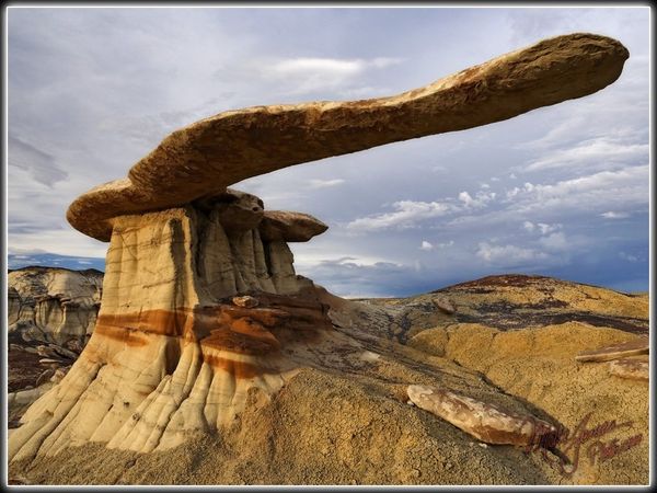
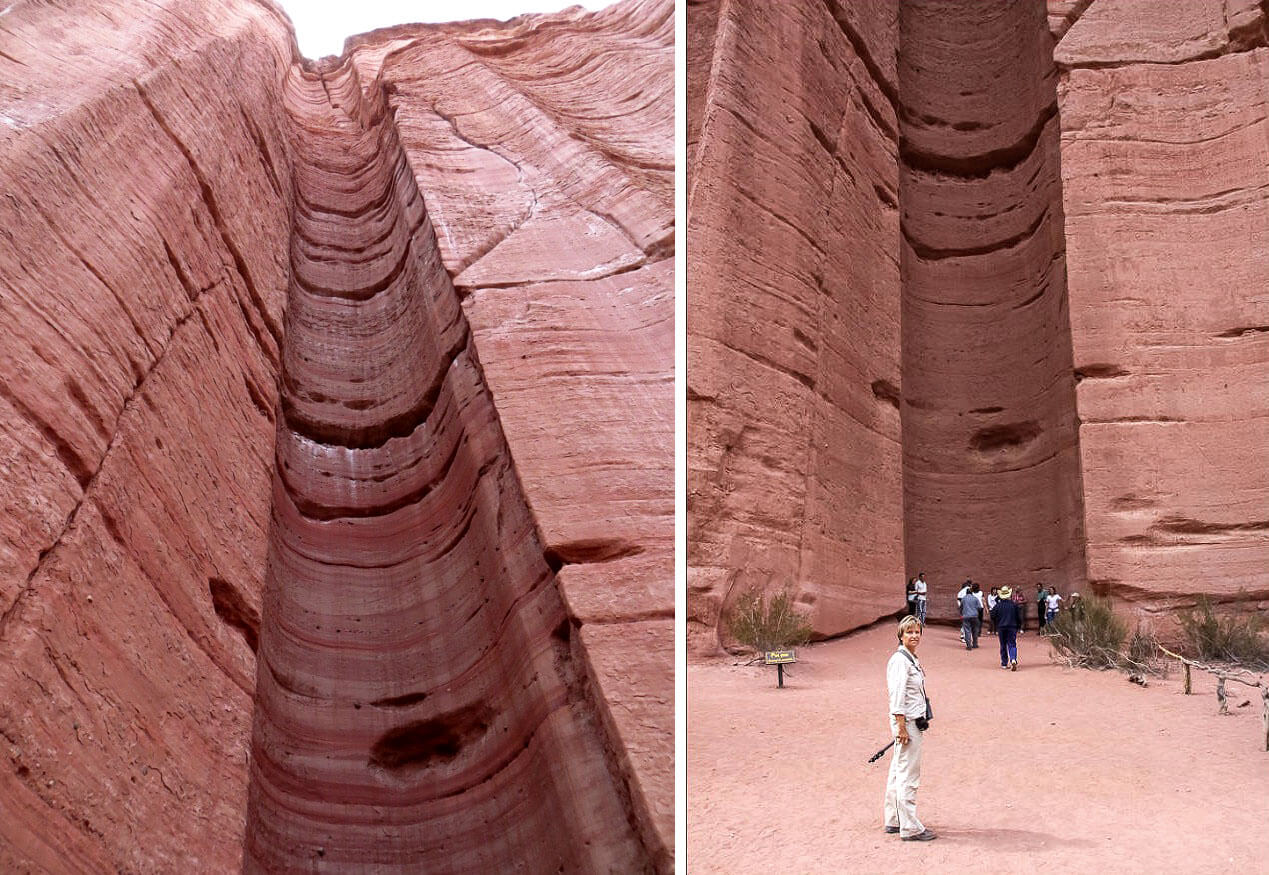
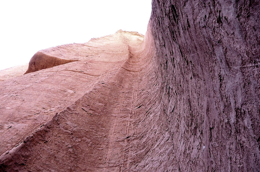
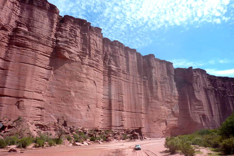
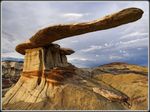
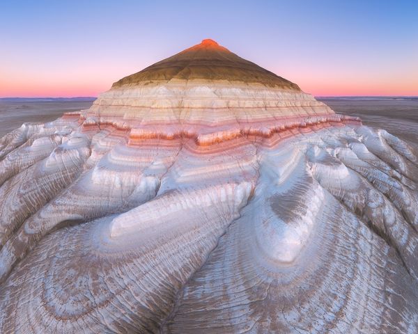
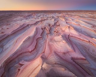
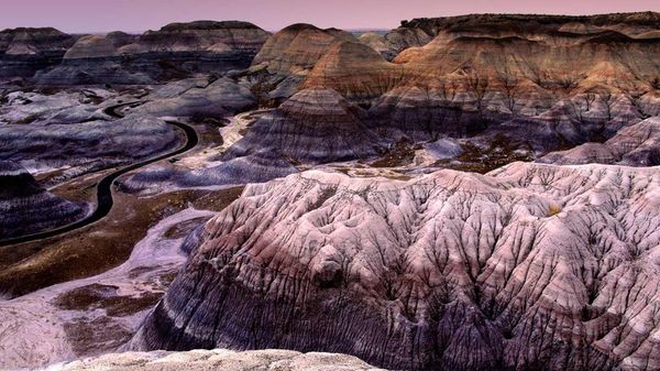
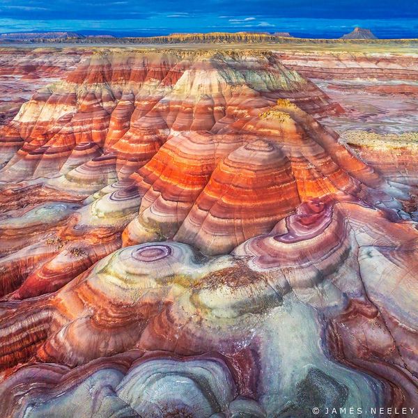
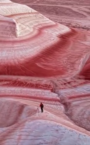
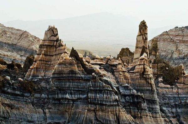
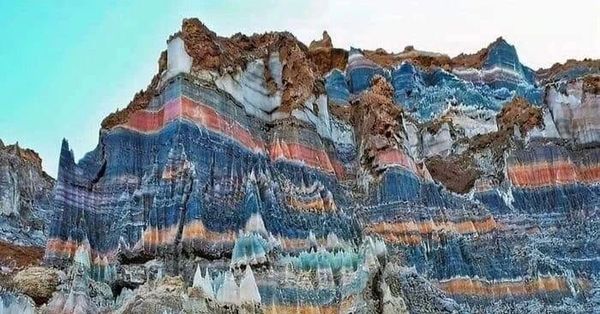
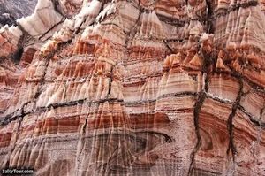
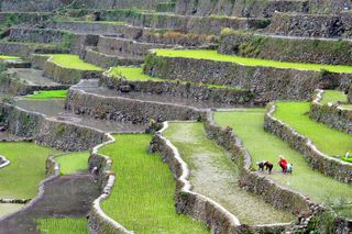
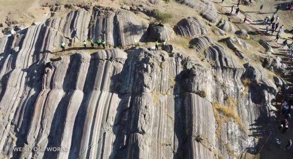
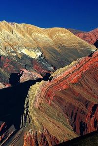
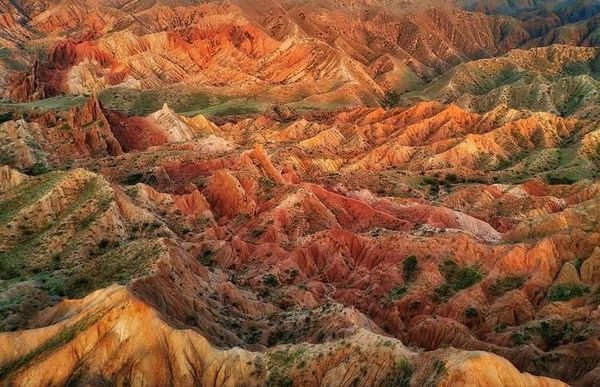
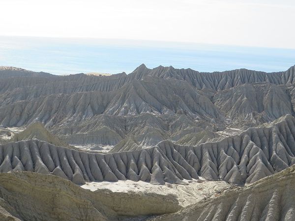
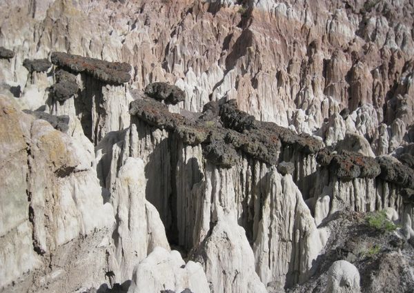
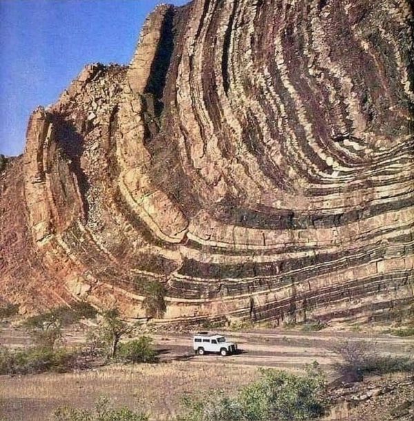
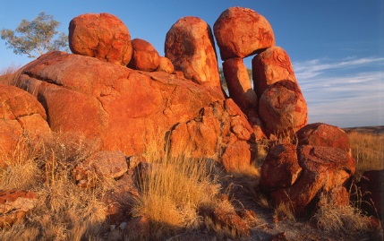
Tiramisu Rocks, near Aktau, Mangystau, Kazakhstan.
Click image for link
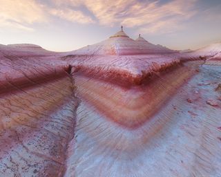
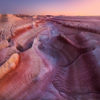
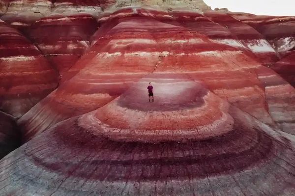
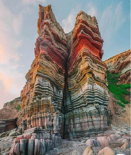
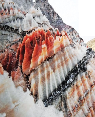
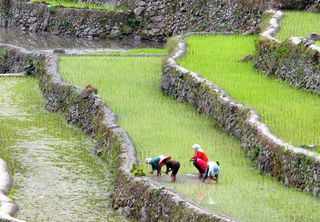
Tiramusu Rocks, near Aktau, Mangystau, Kazakhstan.
Click image for link
Wonders of Mangystau: Exploring Surreal Landscapes 19-27 October 2025
danielkordan.com
Embark on a breathtaking journey through the wild landscapes of Mangystau, a hidden gem of Central Asia, Qazaqstan. This exclusive photo tour invites you to explore surreal desert formations, vast steppe horizons, and ancient cultural landmarks—all through the lens of your camera.
Guided by experienced local experts and led by Arseniy Qashqarov, an internationally acclaimed landscape photographer, you’ll capture the essence of Mangystau’s untouched beauty. Whether you’re a seasoned photographer or an enthusiast, this adventure offers the perfect blend of exploration, creativity, and technical mastery.
Comment: I think this tour operator is set-up to attract photographers.
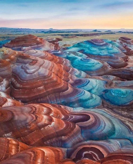
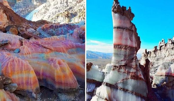
Tiramisu Rocks, near Aktau, Mangystau, Kazakhstan.
Click image for link
|
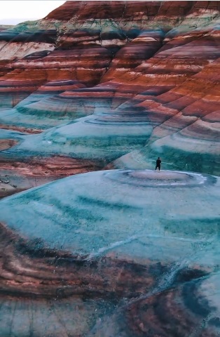
Tiramisu Rocks, near Aktau, Mangystau, Kazakhstan.
Click image for link
|
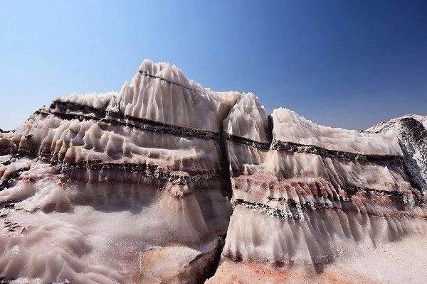
Tiramisu Rocks, near Aktau, Mangystau, Kazakhstan.
Click image for link
|
Tiramisu Rocks, near Aktau, Mangystau, Kazakhstan.
Click image for link
|
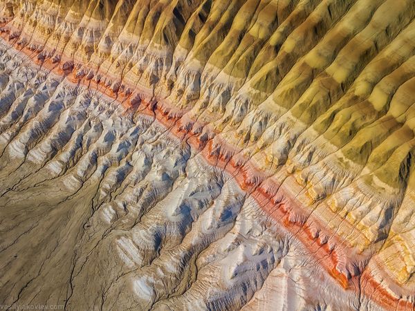
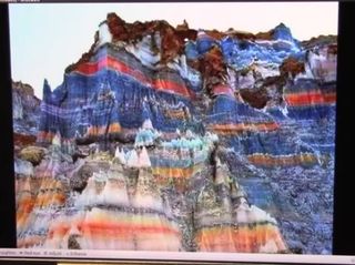
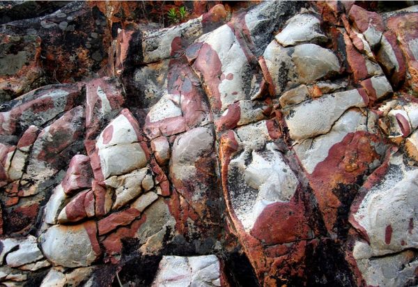
Fascinating Chalky World, Mangystau
Behance, Sep 2015
Mangystau region is located in the southwest of Kazakhstan and occupies significant part of the Ustyurt Plateau. The plateau has magnificent landscape zones of chalk which have been deeply sculpted by weathering and erosion.
Comment: This is about a trip to this other worldly place.
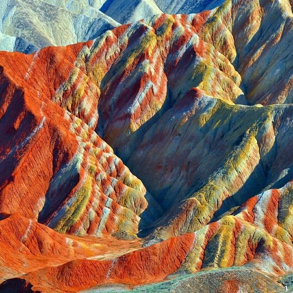
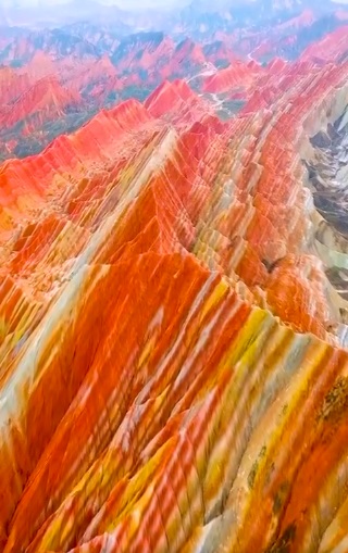
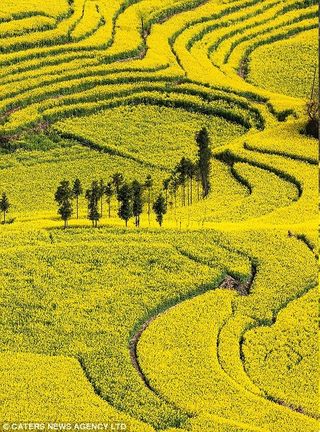
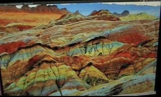
Rainbow Mountains in Zhangye Danxia Landform Geological Park, China
Click image for link
These are the famous Rainbow Mountains in Zhangye Danxia Landform Geological Park in northwest China. These red, yellow, green, blue, pink, and gray hills are the product of deposits of sandstone, iron, and other trace minerals.
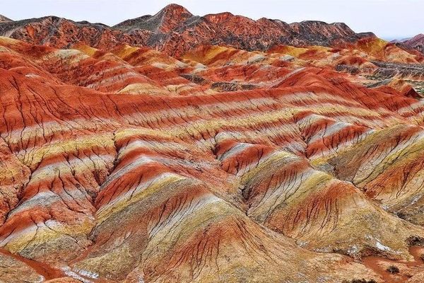
Rainbow Mountains in Zhangye Danxia Landform Geological Park, China
Click image for link
Comment: There is a slideshow here.
Rainbow Mountains In China’s Danxia Landform
Geology In, September 2015
[...] The extraordinary landscape stretches across an area of approximately 510 square kilometers and is part of the larger Zhangye National Geopark. The vibrant colors of the Rainbow Mountains are primarily shades of red, orange, and yellow.
Comment: The colours are probably too bright. More images here.
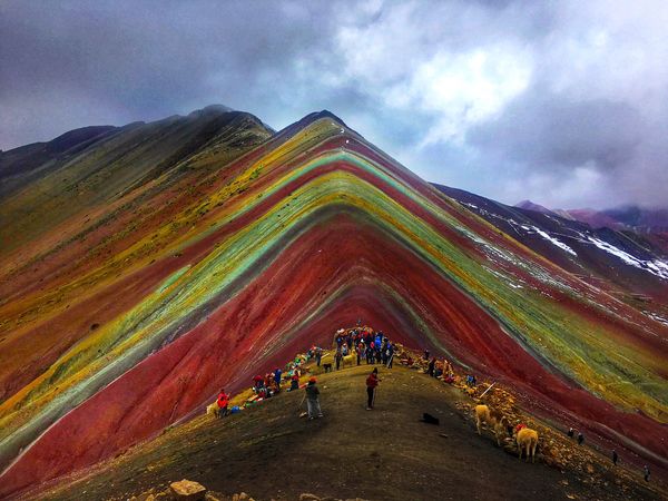
Rainbow Mountain, Peru
Click image for link
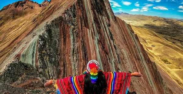
Pallay Punchu, Cusco Peru
Click image for link
Rainbow Mountain: Pallay Punchu, Everything You Need to Know
salkantaytrekking.com, 146th May 2025
Discover Pallay Punchu, Cusco’s unknown Rainbow Mountain. That’s right: in Peru, there’s not just one Rainbow Mountain, but three stunning natural wonders — Vinicunca, Palccoyo, and Pallay Punchu. The latter remains a well-kept secret, a hidden treasure among the landscapes of the Andes.
Comment: More photos that are not as bright.
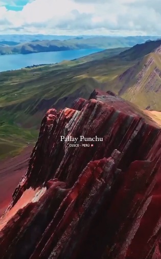
Pallay Punchu, Cusco’s Rainbow Mountain in Peru.
Click image for video link
Comment: An amazing short video on Pinterest Link
|
Rainbow Mountains, Zhangye Danxia Geopark, China
Click image for video link
Comment: Maybe, the colours are too bright here....
|
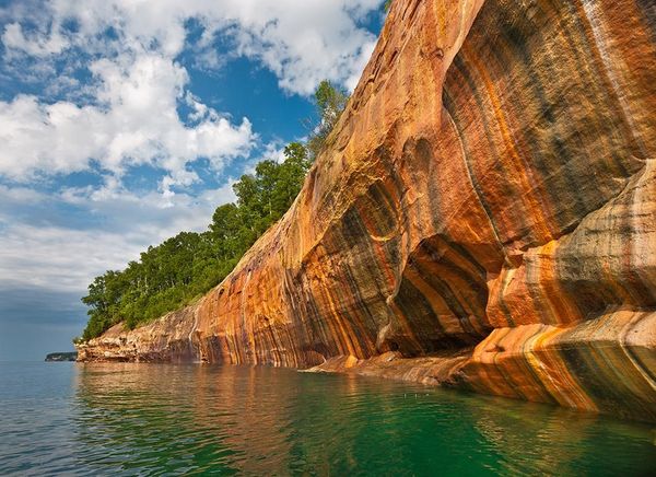
Pictured Rocks National Lakeshore in Michigan’s Upper Peninsula
Click image for link
Comment: Here, the last video captured from the water reveals striking horizontal layering. Some of this is white and other parts are very fleshy coloured.
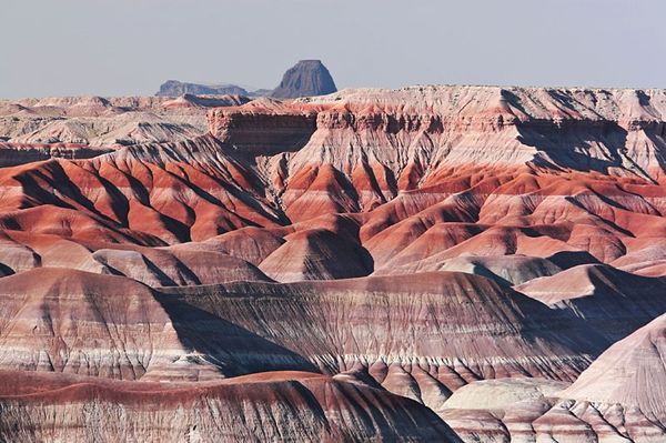
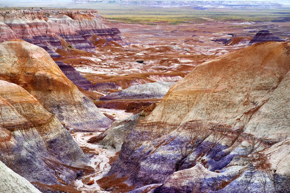
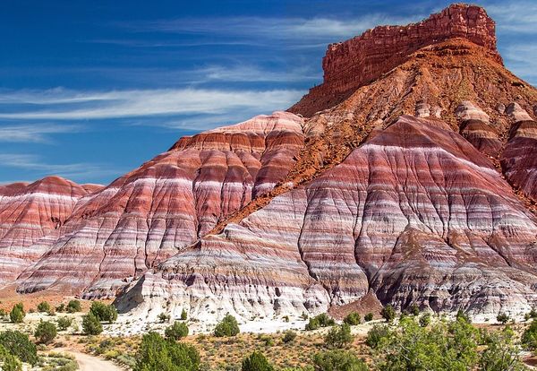
Painted Desert (Northern Region), Petrified Forest National Park
Click image for link
This area is known for its vibrant, multicolored badlands, mesas, and buttes, formed by eroded sedimentary layers. Btw, Mesa means table in Spanish.
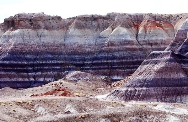
Blue Mesa, Petrified Forest National Park, Arizona
Click image link
The Blue Mesa features striking blue, purple, and gray badlands with a 1-mile loop trail and petrified wood.

Painted Desert in the Petrified Forest National Park, Arizona
Click image for link
Painted Desert in the Petrified Forest National Park, Arizona
Click image for link
Paria River Canyon, Utah
Click image for link
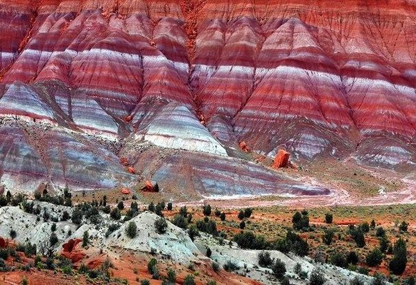
Paria River Canyon In Utah. The Chinle Formation, Paria valley badlands, Utah
Click image for link
Paria Mountains: Rainbow Mountains in Utah
Geology In, July 2016
The Paria River Canyon (Paria Rainbow Mountain) is a stunning geological wonder located in the heart of Utah. The mountains are known for their colorful rock formations, which range from red and orange to purple and white.
Comment: More stunning images of this region here.
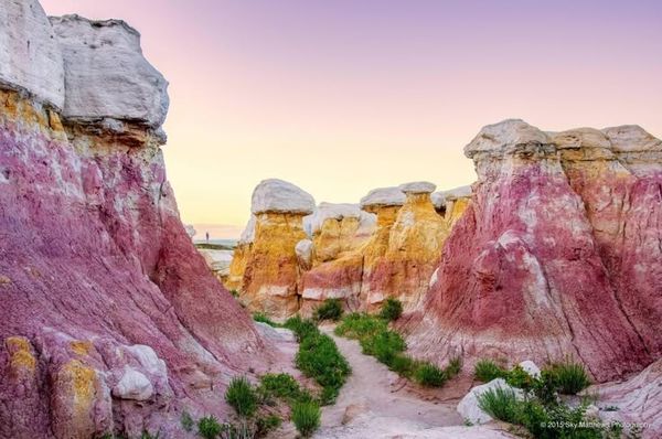
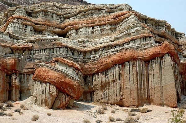
Paint Mines, Colorado, USA
Click image for link
The Paint Mines in Colorado cover 750 acres and features geological formations of hoodoos, colored clay, and sandstone-capped spires. A very odd collection of hoodoos and painted clay, with various wild and clashing colors emerging. The colorful layers of the rock formations are caused by oxidized iron compounds. The Paint Mines are named for their colorful clays that were collected by American Indians to make paint. Hot link link
Paint Mines Interpretive Park
Comment: More images and video of this amazing place...
The Bentonite Hills, Hanksville, Utah.
Click image for video link
The Bentonite Hills in Southern Utah are famous for their rainbow rings.
Click image for link
“The Bentonite Hills appear as softly-contoured, banded hills in varying hues of brown, red, purple, gray, and green. The hills are composed of the Brushy Basin shale member of the Morrison Formation.”
The Bentonite Hills in Southern Utah are famous for their rainbow rings.
Click image for link
Comment: You might also like the Ice Cream Hills, also descibed as “raspberry cheesecake hills” Link
The Bentonite Hills in Utah
Click image for video link
|
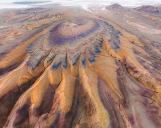
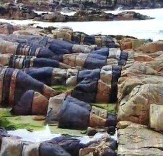
AKTAU MOUNTAINS
Altyn Emel National Park.
Kazakhstan.
Click image for video link
|
Is this New Evidence that Geology is VERY Misunderstood
YouTube, 15 Sept 2021
At one time long ago....Biology met Chemistry and they formed a perfect union called rocks and we now call this Union Geology.
A new un-noticed process called neucleophilic substitution is to blame for this transition to stone and metals and gems.
I think we need more minds on this...geologists have a strong agenda and few have the other skills like chemistry and biology and anatomy to support the conclusions.
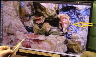
Comment: About half way through this video, Roger Spurr starts to explain how the stripes appear in stabilised tissue after they have come into contact with liquid (usually salt water). He then states that the colours are associated with transition metal complex ions. Hence, the process of tissue stabilisation is a chemical reaction and well understood by chemists. Btw, Roger never seems to stick to one topic for long.
Mudfossil chemistry explained
YouTube, 24 Nov 2016
Timestamp: Muscle Mountain 6:07 Link
(2 mins | Roger explains how the colours occur.)
Timestamp: Transition metals 13:02 Link
(3 mins | Roger details a chemistry paper and explains the capabilities of Transition metals when placed in a solution that includes blood to facilitate stabilisation.)
|
Hosta beach (aka Traigh-stir) on North Uist in the Outer Hebrides, Scotland, UK.
Click image for video (Timestamp)
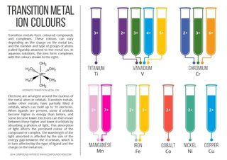
The diagram shows aproximate colours for some common transition metal complex ions.
Click image for video link (Timestamp)
|
Salt Domes & Salt Glaciers Don’t look Like Flesh....
But they don’t look like pure salt either. The mystery continues.
Salt dome Zagros Mountains of Iran
Click image for link
Comment: The Zagros Mountains are a mountain range that stretches from eastern Turkey to southeastern Iran. Hot link image Link
Salt dome of Mount Jashak, Iran
Click image for link
Salt pillar. Zagros Mountains of Iran
Click image for link
Salt glacier and pillar. Zagros Mountains of Iran
Click image for link
Salt glacier Zagros Mountains of Iran
Click image for link
Salt Domes And Salt Glaciers of Zagros Mountains
Geology In, January 2023
Salt domes and salt glaciers are unique geological formations found in the Zagros Mountains of Iran. Salt mountains, also known as salt domes. In the southern part of the Zagros Mountains alone, there are more than 130 salt domes which affected the structure of Zagros Mountains as one of the most significant simple folded systems in the world.
Aside from salt domes, there are salt caves including the longest salt cave in the world at over 6.4 km in the Namakdan Mountain, salt glaciers, salt valleys, karst sinkholes, and salt springs.
Comment: There are more striking examples here of these unique geological formations in Iran with explanations of how they were formed.
Are we Truly the Salt of the Earth if so Where did that Salt come From and What about Salty Blood?
YouTube, 15 Mar 2023
Comment: Despite the religious title and caption, RS talks about the scientific evidence that salt water infused titan carcasses resulted in these so-called salt domes. As usual there is some meandering, but ~14 minutes RS explains that enzymes in the body can break apart molecules and transform them. My interpretation is that RS believes that the initial event was a flood of salt water, but transition metals in the titan flesh and enzymes caused a cascade reaction and transmuted the flesh into a very high percentage of salt Link .
|
Click image for link
Click image for link
Click image for video link
|
.
Ancient Mining By Giants? (Introduction)
Ancient texts explain that initially 450,000 years ago, 50 Anunnaki landed on Earth to work in gold mines. 430-400,000 years ago, this number increased to 600 Anunnaki. Due to the evidence of the size of these operations, it is most likely that the Annunanki were an advanced alien race. However, at some point the Annunnaki decided that the work effort was too much and therefore created humans to do the hard graft.
Zecharia Sitchin (1920 – 2010) is famed for writing a number of bestseller books that explains humans as the creation of ancient astronauts that are also believed to be the founders of the ancient Sumerian culture.
Since many other books have been written on this subject and many articles can be found on the internet, (a few references will be provided here), the point is that mining on this planet has been going on for a very long time. So, the focus here is to provide a summary of the most interesting and artificial geology that resulted from extensive ancient mining.
Yet, due to the passage of time, the results of this ancient mining is often disguised as Nature takes over to revitalise Earth, producing a more natural looking landscape. Still, even after hundreds of thousands of years, the resulting chemical waste can still becomes unstable and volatile. Geologists call those active or intermittent volcanoes. However, that does not mean that all volcanoes are ancient slag heaps, but does explain how lightening and DEWS can set them off.
Therefore, it is fair to suggest that the only difference between mining today and in the ancient past is simply location and scale. For example, there are signs of ancient mining at mountain peaks, so the question is: how did they get their advanced heavy equipment to those locations? The following was inspired by mostly Russian sources and research has spread across the internet as interest grows in this topic. Since, I don’t believe in re-inventing the wheel, the following is just an adequate sample to prove there is an alternative way to understand our surroundings. References are provided mainly for proof of abundant evidence, but the proviso is that the analysis provided may be incomplete or wrong. The saying goes that if you have a hammer, not everything is a nail. In this regard, claims are often made with no real meaningful analysis or scientific grounds. Here the claim is made that the Earth land masses were built up by titan sized carcasses that fell from the heavens and the Mudfossil hypothesis still stands. As a reminder;
Definition: the Mud Fossil hypothesis is an observational science, proposed by Roger Spurr (Mudfossil University) and others, for the apparent resemblance to living entities of some land-forms of the Earth’s continental crust, particularly rocky outcrops of such life-like appearance (mimetoliths), which holds that such resemblances are due to the fact they were living entities, constituting evidence that many (if not all) such mineral forms are composed of the fossilized remains of dead life forms, and, in the case of larger rock formations and mountain faces, that some of these life forms were of enormous size.
The main intent of this section is to point out a sample of artificial geological features created by ancient mining. However, a few false claims of ancient mining will also be cited and the reasons why the record has to be corrected.
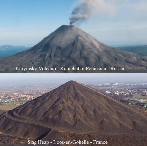
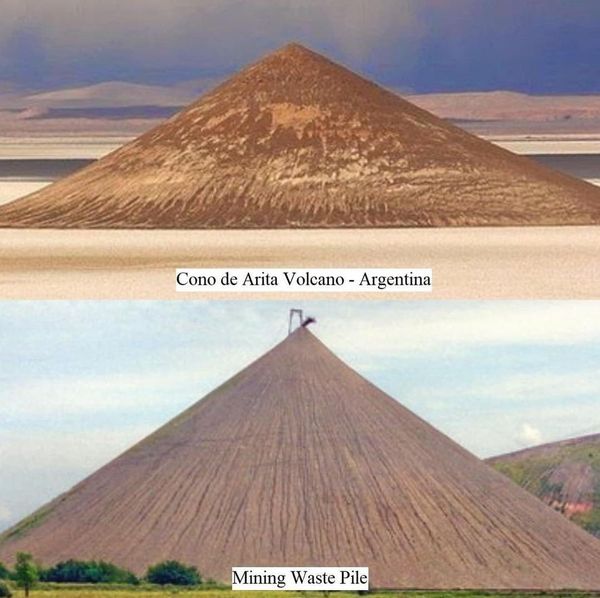
Famous Waste Heaps, Some Volcanic
Briefly, after extraction, only ore with sufficient mineral value is kept and/or enriched, while waste is generally sent directly to a dump (or waste heap) or tailings facility to prevent environmental contamination of chemicals used in the enrichment process. It seems that in ancient times there was no environment concerns and waste heaps were piled up all over the planet. The following are just a few well known examples.
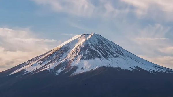
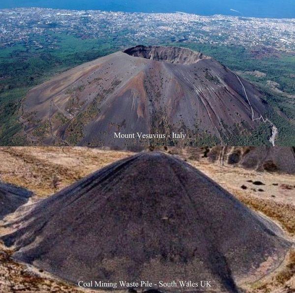
Mount Fuji, Japan
Click image for link
Comment: We are informed that Mount Fuji, is a beautiful active volcano about 100 kilometers southwest of Tokyo that symbolizes Japan. It was called “Fujisan, Sacred Place and Source of Artistic Inspiration” and considered World Heritage by UNESCO. Presumably, primitive people believed it to be the home of a volcano god. However, the reality is that today, some more enlightened folk believe this is a massive slag heap created in ancient times by giants.
Comment: Some claim that Earth is nothing more than an ancient mining quarry and we live in the remains of an excavated wasteland. If we think about our GIANT past, everything was bigger including the excavators. Top pictures are called VOLCANOES
Bottom pictures SLAG HEAPS...Compare.
Mount Etna on the Italian island of Sicily.
Click image for link
Mount Etna: Italy’s Fiery Titan of Geology
Rising over Sicily, Mount Etna’s near-constant eruptions shape the landscape and captivate scientists, a testament to Earth’s restless tectonic forces.
Comment: Due to the obvious selection of chemical components here, every now and then Mount Etna errupts. Please note the other rather obvious looking waste heaps in the background.
CRACK IN ITALY’S ETNA VOLCANO LEAVES SCIENTISTS ON ALERT. FLANK COLLAPSE?
YouTube, 3 Sept 2025
🌋 MOUNT ETNA ERUPTION ALERT: Dangerous New Fissure Threatens Europe’s Most Active Volcano!
Mount Etna, Europe’s largest and most active volcano, is showing alarming signs of escalating volcanic activity. A massive new crack has appeared on the volcano’s flank at nearly ten thousand feet altitude, sparking fears of catastrophic eruptions in Sicily, Italy.
🔥 WHAT’S HAPPENING RIGHT NOW:
New dangerous fissure discovered near Bocca Nuova crater
Intense lava flows reaching seven thousand five hundred feet elevation
Increased seismic activity and ground deformation detected
Italian Civil Protection raises alert to F1 level
Tourist access restricted above eight thousand two hundred feet
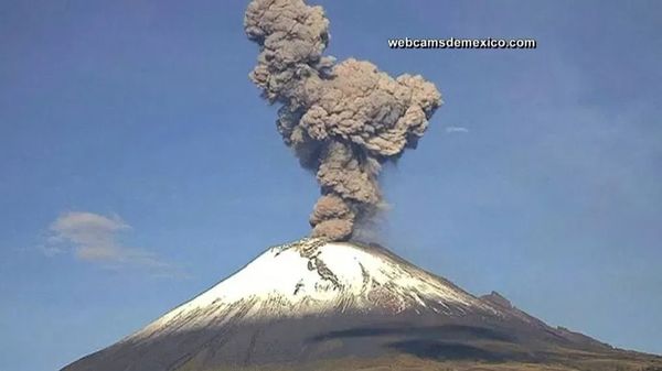
Popocatepetl volcano erupts, Mexico.
Click image for video link
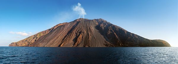
Stromboli vulcanic island. Near Sicily, Italy.
Click image for video link
The stromboli vulcano erupting on the "Sciara del Fuoco" north west side, day shot, blue sky.
Comment: The Italian island of Stromboli located off the coast of Sicily, is one of the world’s most active volcanoes. More info: Are There Any Active Volcanoes in Europe?
Click image for link
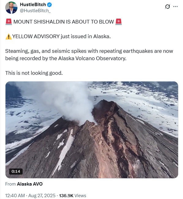
🚨 MOUNT SHISHALDIN IS ABOUT TO BLOW 🚨
⚠️YELLOW ADVISORY just issued in Alaska.
Steaming, gas, and seismic spikes with repeating earthquakes are now being recorded by the Alaska Volcano Observatory.
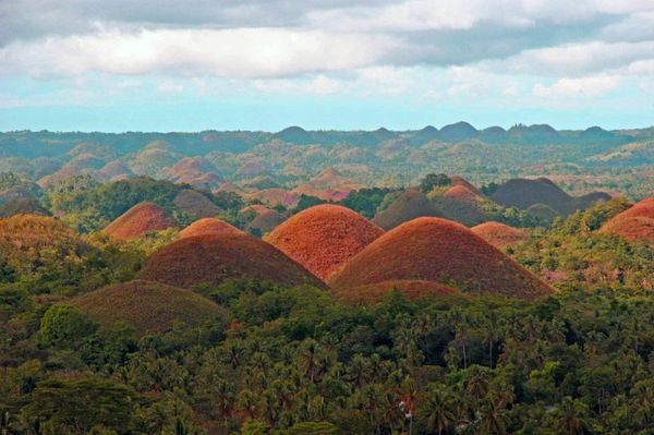
Bohol Island, Chocolate Hills. Philippines.
Click image for link
The island of Bohol is famous due to the “chocolate hills”, which stretch over an area of about 50 square kilometers. In fact, there are 1268 conical shaped hills up to 100 meters high. As beautiful as they look now, these hills were once ancient waste heaps.
Comment: More images on Yandex.com Link
Click image for hot link
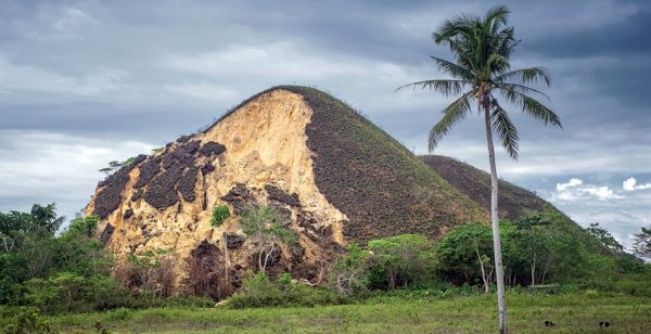
Cause of deadly Philippines quake likely the East Bohol Fault
NBC News, Oct. 15, 2013
A deadly magnitude-7.1 earthquake struck the central Philippines on a national holiday Monday.
Comment: Apparently, the hills are formed of limestone, but underneth the ground is clay! This means that the hills appeared only after a layer of fertile soil was created. The hills have a rather loose structure, as proven by heavy rain and earthquakes.
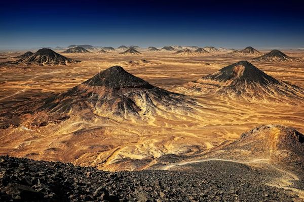
Egypt’s Black Desert
Click image for link
Comment: Here we are informed, “Thanks to a centuries-old volcanic explosion, the tops of mountains in this northern Egyptian desert bear the colour black.”
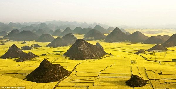
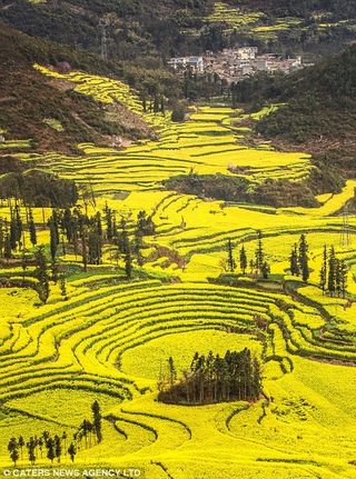
Rapeseed grown in China
Click image for link
China’s other yellow river: Worldwide march of rape seed overwhelms the paddy fields
Daily Mail, 18th October 2012
The rush for rapeseed which has turned much of Britain’s countryside into a sea of gold for several months every year appears to have spread to China.
These striking images show huge swathes of land in the country’s southern Luoping area covered with the distinctive crop, which has proved to be a popular biofuel.
Comment: Here we see a former mining waste site being used to grow rapeseed. The only indication that this is an ancient mining site is that the heaps have become overgrown with vegetation.
|
Painted hills 1, Oregon, USA
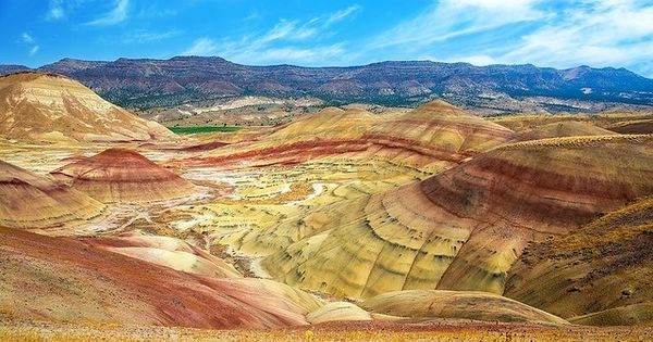
Painted hills 2, Oregon, USA
Comment: Very difficult to decide what is going on here. Painted Hills 1 is mostly like waste heaps, but Painted Hills 2 could be untouched, because these hills look like they are in normal transition states.
Landscapes ravaged by giant excavators
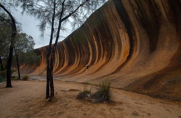
Wave Rock, Australia.
Click image for link
Wave Rock is a 15 metres high and 110 metres wide rock formation in Australia that is shaped like an ocean wave. This is the official narrative:
The age of Wave Rock is mind-boggling – it is 2.63 billion years old, made of granite, with multi-colored stripes created by the rain washing chemical deposits, carbonates, and iron hydroxide, down the face of the rock, forming vertical stripes of greys reds, and yellows. The wave-like shape was formed by the gradual erosion of the softer rock beneath the upper edge over many millions of years.
Source: Facts About Wave Rock In Australia
15 MOST Unbelievable Rock Formations From Earth’s Past
YouTube
Comment: We are given the official geological explanation here of flared slope weathering of granite over millions of years. Well, despite the belief that this is a natural formation, it can be easily compared to landscapes ravaged by an excavator.
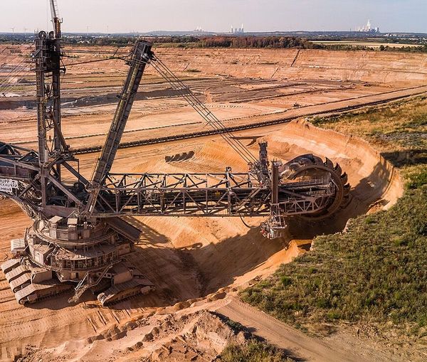
RWE Power AG excavator 291 in the Hambach opencast mine in August 2018.
Click image for link
Comment: This image is cropped. Note the wave shaped rock remains.
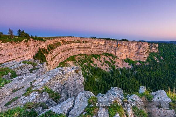
Creux-du-Van, Switzerland.
This is a less obvious wave rock.
Comment: The official narrative is that Creux-du-Van, is a giant rocky, horseshoe-shaped depression 1400 meters wide and about 200 meters high. It is considered a natural amphitheater formed as a result of erosion of rocks in the Jura mountain range in the canton of Neuchâtel. Maybe the truth is that Creux-du-Van was created by the use of a bucket wheel excavator working on limestone in Switzerland. The bucket wheel spins as it’s held up against a cliff, picking up material and dumping it onto a conveyor belt in the excavator’s arm. That belt empties out onto giant dump trucks on the ground that move the material away from the mining site.
Mount Watkins, Yosemite National Park
Click image for link
On our planet, on every continent, you can find a huge variety of places supposedly created by nature, which are very reminiscent of modern mines and quarries. The first picture is of Mount Watkins. There, excavations of rock on a huge scale that nature cannot create are all too obvious. This particular place is very popular, in terms of possible ancient quarries. Let’s compare. Next is a photo with the traces of a rotary excavator. Does it look like? Scientists mistake places like this for natural formations. It seems to me that in the past, the Earth was mined as best they could, and now the same thing goes on. Only when this civilization existed, unfortunately, one can only guess.
Comment: Please note that Watkins is not a mining company; however, historically, several entities with “Watkins” in their name or connected to individuals named Watkins have been involved in mining operations.
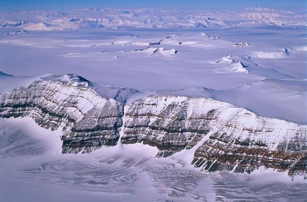
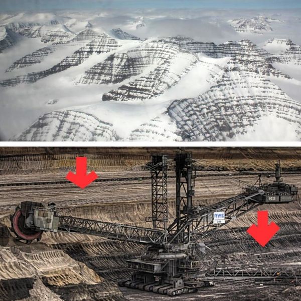
Trans-Arctic Mountains, Antartica
Comment: This is how I imagined the results of ancient mining would look like.
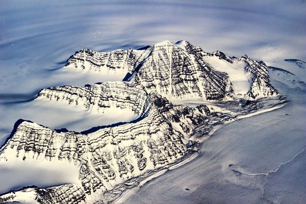
Watkins Mountains, Greenland
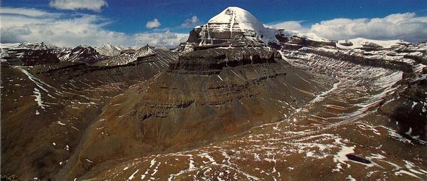
Mount Kailash, Tibet
The height is 6638 meters! Is heavy mining equipment lifted to such a heights in our modern world?
Goblin Valley, Utah
Comment: Why were blocks left behind?
The Monument Valley Navajo Tribal Park, Arizona Utah
Click image for link
Comment: If Monument Valley is the result of ancient mining, why were these monuments or stumps left? Dr Philipp Druzhinin is a blogger who does a lot of videos about the ancient world. He speculates that in recent times, stumps were left in order to calculate the volume of soil removed, see video (timestamp) Ancient quarry.
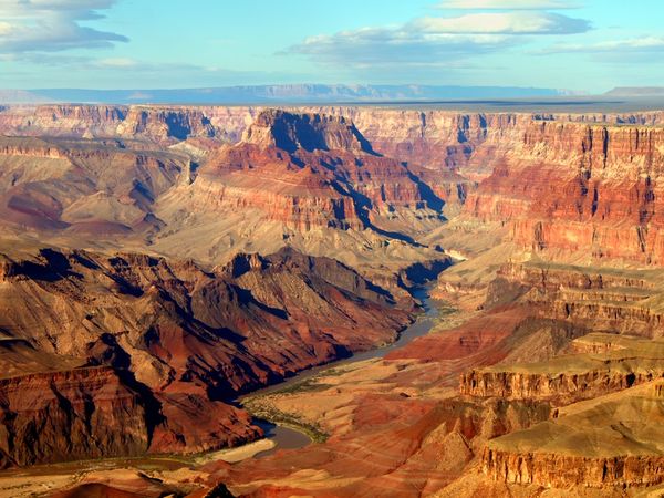
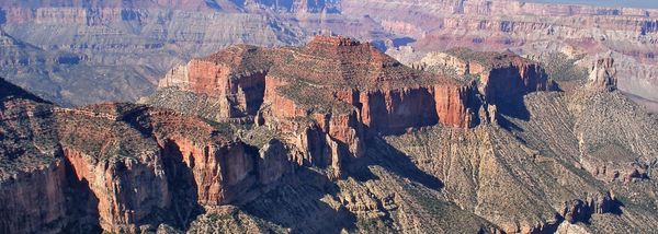
Grand Canyon
Click image for link
Comment: Apparently, the origin of Grand Canyon is a mystery unexplained by uniformitarian geology. How old is Grand Canyon?
The Geological Strata Mystery: Where did all that ROCK come from?
3rd February, 2016
Global 2-8 KM deep rock strata! An unexplained enigma!
When I looked at this picture above, at the multiple rock strata of the 2 km deep gouge into the Colorado plateau of the Grand Canyon, something suddenly struck me. I began to wonder how all these thick layers of rock were ever laid? At first I only wondered, “How did the geological strata come into existence?” But when it suddenly dawned on me that these strata are not just down in the Grand Canyon, but that there are kilometers-deep strata existent below our feet worldwide under every continent, I had an epiphany! “Where on earth did all that kilometers deep dirt come from? Where did it originate? Did it fall from space? From other planets? Was it dug from the holes the oceans are in? Or what?! It must have come from somewhere! But from where?”
Comment: There are a variety of mysteries associated with the Grand Canyon. Here, the focus is the sheer volume of rock which geologists cannot adequately explain. The article states; “We’re talking a mile thick shell below our feet that used to be above ground level! For that migration of stuff, nature needs a huge kinetic machine or mechanism to cause such horizontally even layers as observed! Forget local floods!”
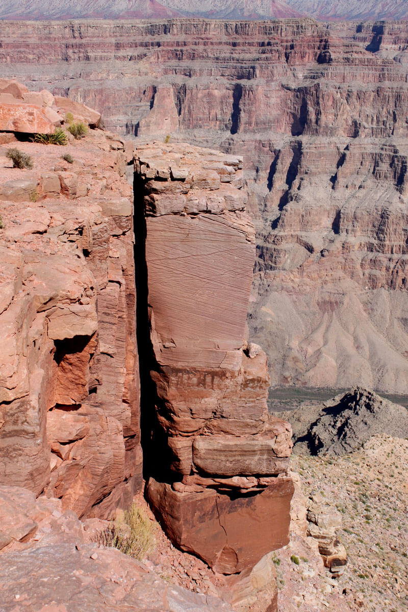
Atoko Point, Grand Canyon National Park
Click image for link
Grand Canyon’s North Rim has many named points - projecting promontories at the edge of the plateau - but comparatively few are easy to reach, as the terrain is much more uneven, split by deep side canyons, and accessible only by 4WD tracks.
Comment: Click links for more North Rim Views.
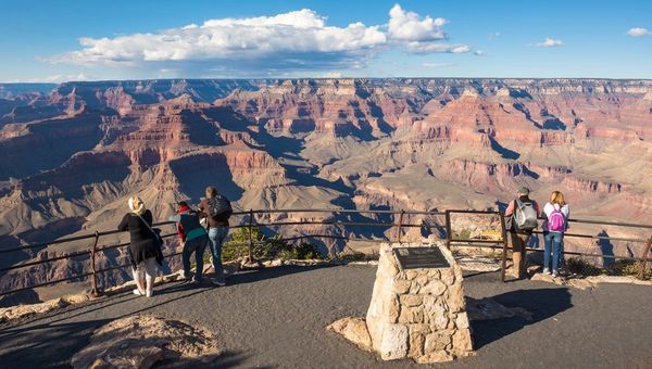
Grand Canyon National Park’s South Rim Visitor Viewpoint
Click image for link
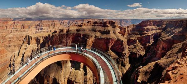
Grand Canyon Skywalk
Click image for link
The Grand Canyon Skywalk is located at Grand Canyon West’s Eagle Point on the Hualapai Reservation and is not affiliated with Grand Canyon National Park.
Comment: Slideshow
Link

Grand Canyon
Click image for link
Comment: Vertical cut by saw.
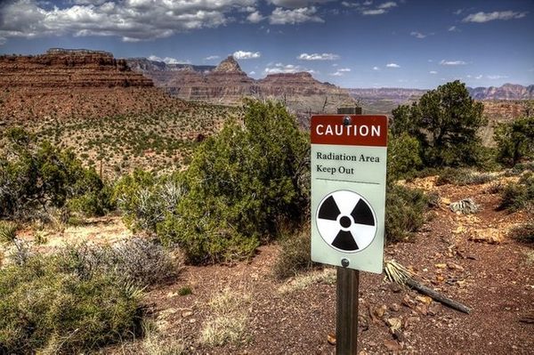
Grand Canyon radioactive warning sign.
Click image for link
Mind-blowing! Grand Canyon - An ancient quarry for industrial extraction of Uranium.
Steemit, 2018
Comment: Many have concluded that The Grand Canyon is the result of ancient mining and it is still in the zone of maximum concentrations of Uranium in the USA. This link is a blog about Ancient Mining, but it starts with information about the Grand Canyon that includes Uranium mining reserves and maps of uranium concentrations.
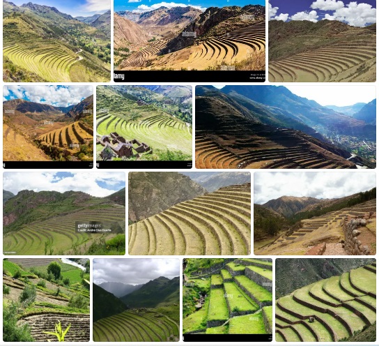
Terrace Farming, Ancient Mining Adaptation?
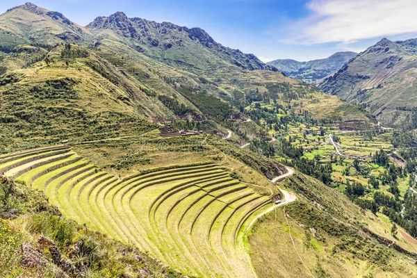
Terrace farming at Pisaq, near Cusco, Peru.
Click image for link
Pisaq is a vast complex of ancient buildings and terraces on top of a mountain near Cusco, Peru. Although most was the work of the Inca, the megalithic elements were created by a much older civilization that had Lost Ancient High Technology.
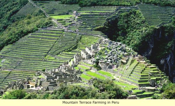
The farming terraces of the Inca Empire, Machu Picchu, Cusco, Peru
Click image for link
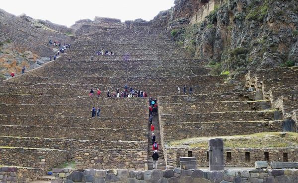
Terraces at Ollantaytambo near Cusco, Peru
Click image for link
The Ollantaytambo ruins are located in the Sacred Valley of the Incas, near the town of Ollantaytambo, about 60 kilometers (37 miles) northwest of the city of Cusco.
The ruins consist of a large complex of terraces, temples, and other stone structures built into the side of a mountain. The most notable feature is the massive stone staircase leading up to the Temple of the Sun, which according to the experts was used for astronomical observations. The staircase is made up of over 150 steps, and is considered to be one of the most impressive feats of Inca engineering and one of the most well-preserved examples of Inca stonework.
More info: Link
Comment: Who built these giant terraces? Was the whole site built by giants and then adopted later by normal sized humans, hence the two sets of steps?
Even More Ancient Megalithic Wonders In Cusco Peru That The Inca Found 1000 Years Ago
YouTube, 23 Aug 2018
Comment: Terraces at Pisaq. 8 - 10 ft tall and at Ollantaytambo each terrace is at least 12 ft tall.
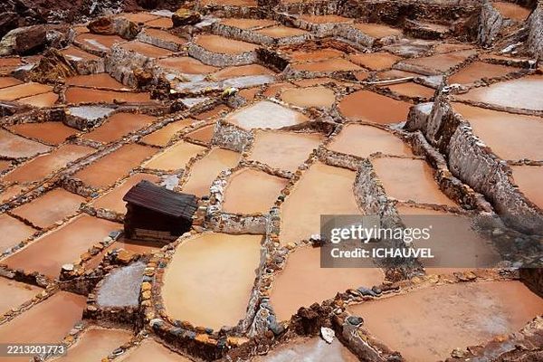
The Maras Salt Flats Peru
Click image for link
In Maras, there is salt—lots of salt from an underground spring rich in minerals. Its waters flow into thousands of pools or ‘pools’ built on stepped terraces on the slope of the Qoripujio mountain.
There are over four thousand of these pools, each with a different size and shape. In this ‘swarm’ of pools, the local people collect large amounts of salt by hand. They are not the first; the extraction of this mineral dates back to pre-Hispanic times. More info: Maras: a salt flat in the mountains
Comment: Yes, very strange.... Rather like Himalayan salt is mined inside a mountain.
Yandex search: Terrace+farming+Peru
Click image for link
Yandex search: Terrace+farming+Vietnam
Click image for link
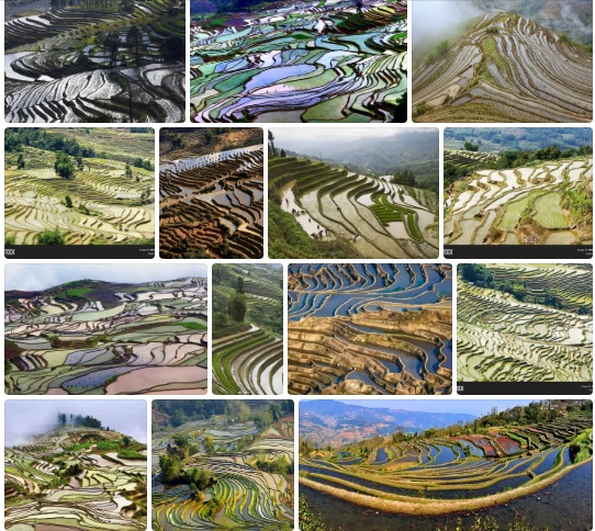
Yandex search: Terrace+rice+fields+Yunnan+Province+China
Click image for link
Terrace Farming [34 photos]
Insteading, 6 May 2016
Comment: This article is about terrace farming in China, Vietnam and Peru. Yes, the bright colours of the paddy rice fields in China are real.
Rapeseed grown in China
Click image for link
|
Rapeseed grown in China
Click image for link
|
China’s other yellow river: Worldwide march of rape seed overwhelms the paddy fields
Daily Mail, 18th October 2012
The rush for rapeseed which has turned much of Britain’s countryside into a sea of gold for several months every year appears to have spread to China.
These striking images show huge swathes of land in the country’s southern Luoping area covered with the distinctive crop, which has proved to be a popular biofuel.
Comment: Here, we can clearly see ancient terraces that are now being used to grow rapeseed.
|
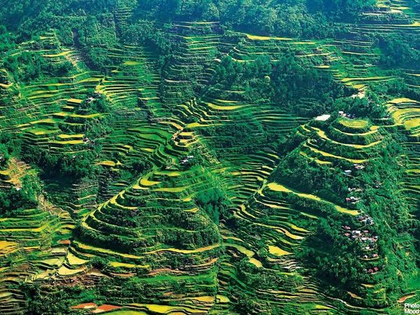
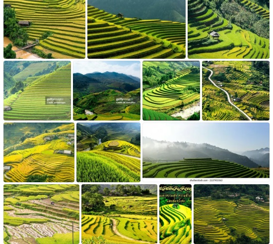
Banaue Rice Terrace, Philippines.
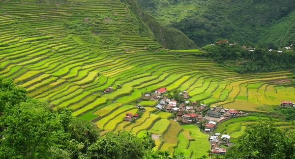
Banaue Rice Terrace, Philippines.
Comment: If these terraces were ancient and the result of mining by giants, maybe we should consider that these terraces in the last few thousand years were repurposed for growing rice.
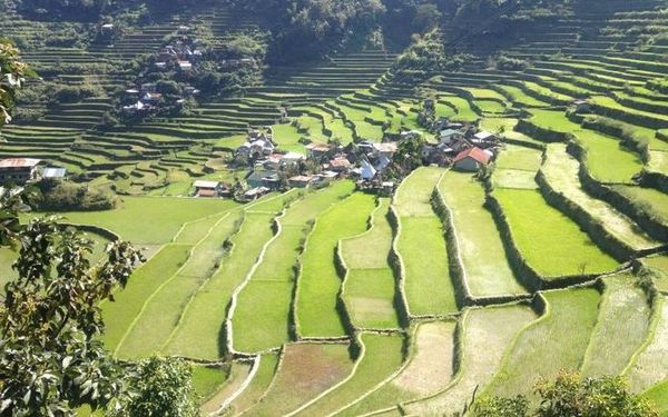
Banaue Rice Terrace, Philippines.
The location of the rice fields are at an altitude of 1,500 meters above sea level.
Comment: More images at Yandex Link
Click image for link
|
Click image for link
|
Heritage of the Cordillera [35 photos]
unchartedphilippines.com
Comment: Images of the Cordillera mountain region of the Philippines
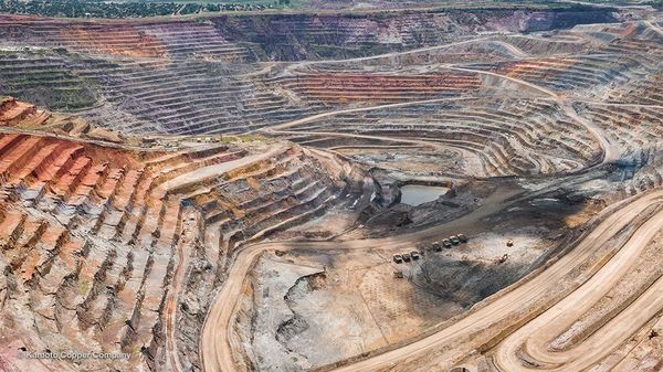
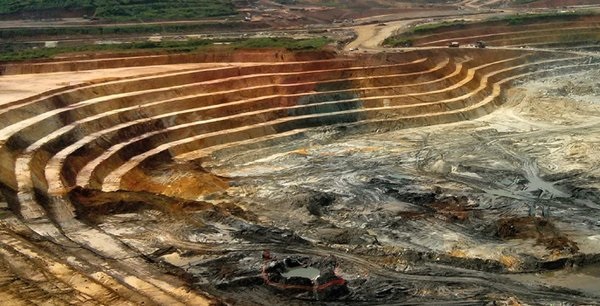
Kamoto copper and cobalt mine in the Democratic Republic of Congo.
Click image for link
Left: Copper Mine.
Right: Unknown Mine
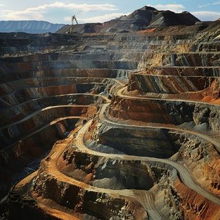
Open pit copper mine, Ely, Nevada, USA
Click image for link
Iron ore mine. Kayseri, Turkey
Click image for link
Aerial view of Open-pit iron mine in Kayseri, Turkey. Taken via drone.
Fimiston Open Pit in Kalgoorlie, Australia.
Click image for link
The giant Super Pit or Fimiston Open Pit in Kalgoorlie, is the largest open pit gold mine of Australia.
Granite mine, Amhara, Ethopia, Africa
Click image for link
Comment: It’s not difficult to imagine that ancient mining took place on this planet and the scars can be compared to more recent activity.
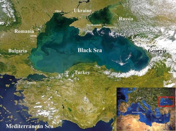
Black Sea, satellite image.
Click image for hot link
The Black sea is located between Europe and Asia. Countries bordering this sea include Bulgaria, Georgia, Romania, Russia, Turkey and Ukraine. Seas that connect to it include the Sea of Azov (upper right) and the Sea of Mamara (lower left).
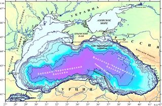
Black Sea map in colour,
Click image for link
Ancient quarry - Black Sea, Russia
YouTube, 4 Jul 2018
Comment: If the Black Sea were to be drained, the result woud be strikingly reminiscent of a massive, man-made quarry. Dr Philipp Druzhinin does a lot of videos on Ancient mining, but I don’t agree with everything because the Mudfossil Hypothesis is not taken into account.
Right: Old photo of Corta Atalaya (1980), when it was in operation.
|
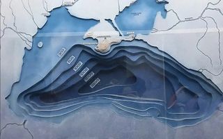
Black Sea depth map
Click image for link
Approximate scheme of the structure of the Black Sea relief. Gentle slopes and a deep pit
Riotinto-Nerva mining basin, Spain
Click image for link
|
Rio Tinto mine and surroundings, Huelva, Andalusia, Spain.
Click image for link
Aerial view of Corta Atalaya, next to the municipality of Minas de Riotinto. This area along the Rio Tinto, in the Andalusian, Spain has been mined for copper, silver, gold, and other minerals.
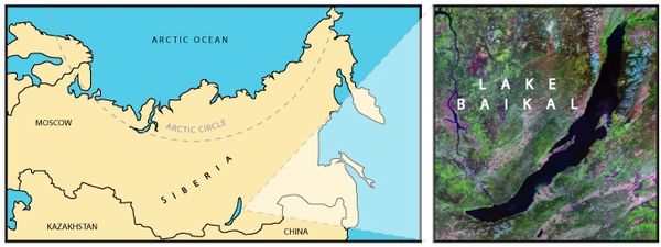
Lake Baikal, Siberia, Russia
Click image for hot link
Lake Baikal is the deepest lake on Earth, plunging to 1,642 meters (5,387 feet). It contains over 23,000 cubic kilometers (5,670 cubic miles) of unfrozen freshwater—about 20% of the planet’s supply. Remarkably, it holds more freshwater than all of North America’s Great Lakes combined. Nestled in Siberia’s rift valley, geologists claim that its depth and diverse ecosystem have been shaped by tectonic forces for over 25 million years. and continues to expand.
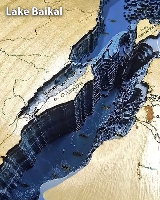
Depth map, Lake Baikal, Russia.
Click image for link
Comment: The sides of this deep lake looks like they have been created with an excavator. The geological explanation of a rift valley does not seem to fit the evidence.
The Geography of Lake Baikal explained
YouTube, 6 Jan 2025
Easily the most fascinating lake of our planet, Lake Baikal is an absolute freak of nature. Nestled into the tectonic rift of the Amurian and Eurasian plates, this 600km long giant is the deepest, most voluminous and oldest lake in the world, so in this video we will drive into many of its peculiar stories.
|

Mine. PHALABORWA LIMPOPO PROVINCE, SOUTH AFRICA
Click image for link
The world’s largest open cast mine site PHALABORWA LIMPOPO PROVINCE SOUTH AFRICA
Comment: Ths might give an indication that deep and steep-sided mines are not unusual.
|

Click image for video link
Introducing Mponeng…
The deepest goldmine in the world 😲
Comment: The Mponeng mine in South Africa is ~3.8 km below the surface with plans to extend the mine to beyond 4.2km in the coming years.
Adobe Stock images with the search term “mining terraces.”
Link.
|
Megalithic polygonal stone masonry & ancient scoop marks

Click image for link
Megalithic ancient polygonal stone masonry without mortar from around the globe. It was not just a singular phenomenon, but widespread across many cultures...

Click image for link
(2 of 4) While many theories credit lost technologies or even aliens, a hypothesis published in 2017 by researcher Helmut Tributsch suggests the Incas may have used an acidic paste made from sulfide-rich mining byproducts to soften stone surfaces, allowing the blocks to fit together seamlessly under their own weight. | XTwitter Link
Comment: Helmut Tributsch’s idea is closer to the Mudfossil hypothesis than most.

Click image for link
This dismantled wall from Pisac clearly shows on the upper face of stones the irregular “impressions” of the overlying stone blocks taken away. How were they produced?
Comment: Actually, I was struck by the dark red/purple glittery “mud”. It reminded me of the beach sand at Hormoz Island, Iran. So did the Incans make some of their walls using partially congealed titan artery blood filled with transition metals?
On the reddish, glittery mud the Inca used for perfecting their stone masonry
Journal name: Journal of Earth Sciences & Environmental Studies, Dec 2017
Megalithic Seamless Perfect walls explained
YouTube, 26 Dec 2017
Mudfossil University...using DNA certification (3) and cat scans (7) and lab chemistry as well as anatomist certifications has well proven Giants and every claim made by MFU. NO GUESSES at MFU...we close cases.
From Egypt to Peru Huge Megalithic unexplained (until now) structures and formations are largely ignored as the origin has not been understood. Biology is the origin.
Comment: RS thinks he has the answer. The rocks were cut when they were wet, rather like current times when people extract peat logs from peat bogs.... Obviously, RS gives the Mudfossil theory of how easy this was to do. The earliest RS YouTube video I found on megalithic walls is from Dec 2016, Megalithic wall BUMPS are now understood

Coricancha Incan Stonework, Cusco, Peru.
Click image for video link
Perfectly level precision squared nubs in this section of the Coricancha’s curved andesite outer wall.
Coricancha is located in Cusco, Peru. It was the most important temple in the Inca Empire, dedicated to the sun god Inti.
|

Cusco, Peru Incan Polygnal Stonework
Click image for video link
Comment: @Newsgirly replied: “Are those massive finger prints?” Link
Yes, have a look. Hmmm.... Update: Video of gouge marks on stone at the Inca fortress Sacsayhuaman Link
|

Click image for video link
How Was Solid Granite Scooped Out Like Ice Cream In Ancient Egypt?
Comment: 41 seconds video clip.
Ancient Technologies Ep. 2 - FORBIDDEN ZONES on the Giza Plateau
YouTube, 30 Jul 2025
Comment: Apparently, the scoop marks on these megalithic stones can be found around the world. The timestamp here starts with bloggers discussing the megalithic blocks of the Menkaure pyramid, which is the smallest of the three main pyramids of the Giza pyramid complex, located on the Giza Plateau.
The obvious scoop marks and the nubs (tendon straps that were simply cut off) are pointed out. Then the cut and groove blocks that were previously hidden inside the walls, but are now lying around, are discussed and this causes even more consternation. It implies that the pyramid builders also had access to mudfossil tendons when they were still moist..... Obviously, this causes massive problems with the official explanations of how the Egyptians made the pyramids.... It seems that these observations strengthen the Mudfossil hypothesis by clearly explaining the major issues that are being pointed out by truthseekers.

Click image for video link
This is one of the weirdest parts of the ancient site of Saqsaywaman in Cusco, Peru! Precision cuts into incredibly hard (7/10) Diorite rock.
This was not done with Bronze tools or stone hammers.
Comment: Language warning!! The truth in plain sight... The diorite rock was not hard when the slabs were cut.
Shocker of Biblical Proportions
YouTube, 26 Aug 2024
Comment: Link (timestamped) starts where RS provides some examples of tyre marks left in granite that reveal mining was undertaken using unknown technology when the whole Earth was still wet. Next, he explains how slabs were removed from tendon. Different wall structures are examined.
|
Tyre marks found on granite. Fuerte de Samaipata, Bolivia.
Click image for video link
|

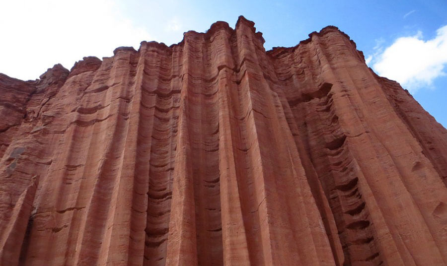
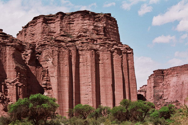
Talampaya National Park, Argentina.
Click image for hot link
Comment: Vertical machining creating massive scoop marks in wet tendonous material?
Strange rock formation near the Inca fortress Sacsayhuaman, near Cusco, Peru
Click image for link & video link
Can a Geologist explain how this stone was formed?
Looks like they were extruded from the ground like playdough or something. When I was there I tried to look for any explanation but I couldn’t find one. They’re fascinating
Comment: Presumably, machinery and/or a vehicle went across this slope when it was very wet. Easier to see possible tyre impressions when the drone is more or less directly overhead at the top of the slope.
Salt Flats & Sludge Tanks
Please find some great pictures and info in this article Mind-blowing! Grand Canyon - An ancient quarry for industrial extraction of Uranium
Link
and use the search term Salinas Grande.
Limestone Quarries & Ancient Mining Evidence
Please find some great pictures and info in this 4-part series (Part 3)
Mountains, mines, terricons - traces of ancient mining (3.díl)
Link
Ancient Mining: Debunking Claims
Click image for link
|
Click image for link
|
Click image for link
|
Click image for link
|
Is the Earth an Ancient Mine? A Look at Familiar Things from a Different Angle.
Spletnik.ru, May 5, 2018
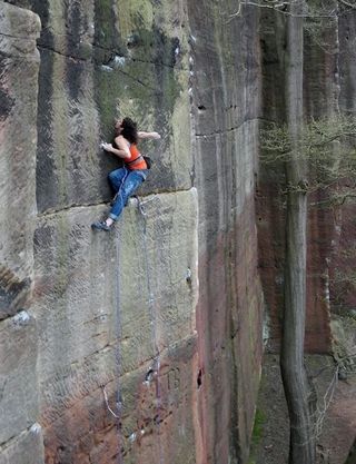
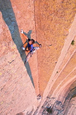
Comment: OK, some bloggers believe that huge flat, smooth angular blocks are evidence of ancient mining and then state they were machined tooled in place for a reasons not known. Yes, there are examples of huge blocks that have the marks of a circular saw and center grinding, but that is different and can be classified as real evidence. The Mudfossil hypothesis states that we are seeing the remains of titans on Earth. Again the theory states that the macroscopic can be compared to the microscopic. Hence these huge outcrops can be seen to be made up of blogs, just like human tendons under the microscope can be seen to be made up in blocks.
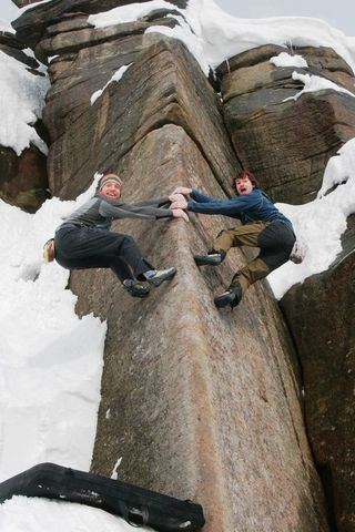
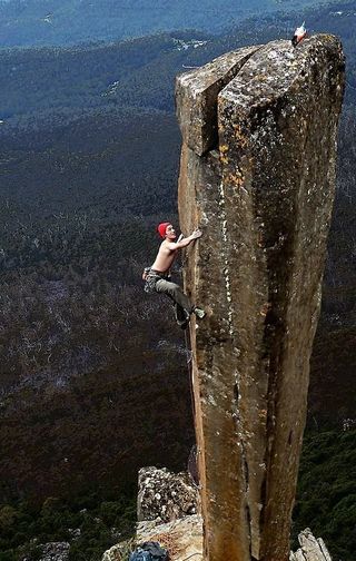
This webpage has a lot of interesting information related to ancient mining, but it starts with 13 images of climbers on vertical cliffs. I believe they are the remains of titan tendons except one (image seen above right) that seems to have a long and thin pinnacle and therefore might be some petrified bone sticking out of the surrounding petrified muscle.
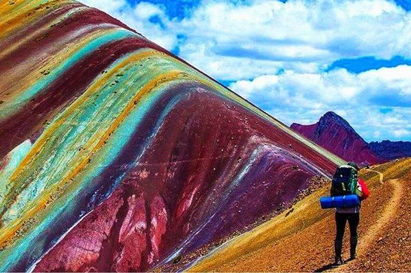
Rainbow_mountain, Vinicunca, Peru.
Click image for Getty images
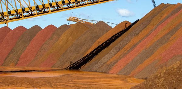
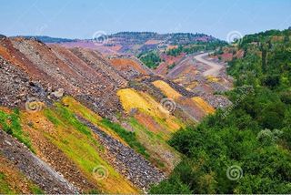
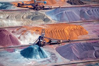
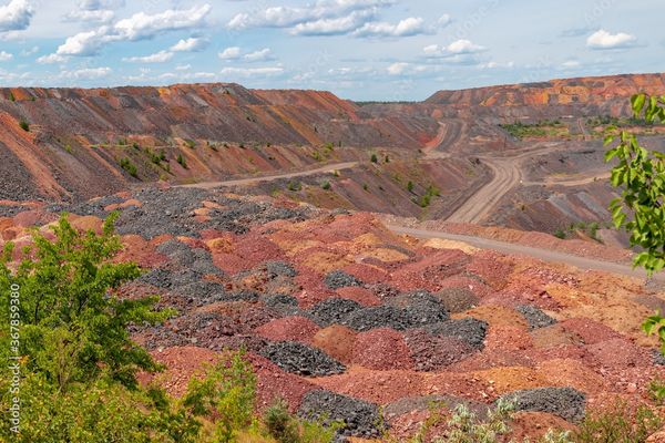
Iron ore conveyer belt heaps
Click image for link
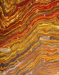
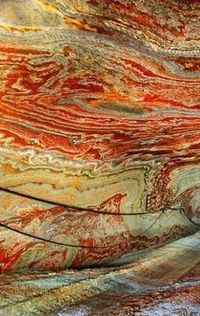
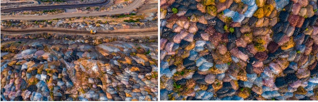
Left: Hornocal Mountains, Argentina | Middle: Colorful polished banded iron formation | Right: Psychedelic salt cave near Yekaterinburg, Russia
Click image for link
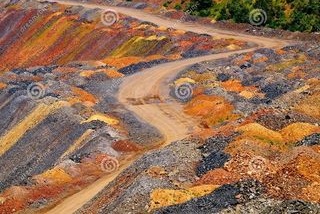
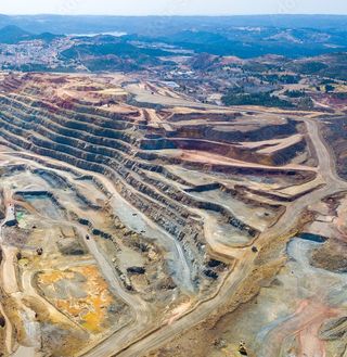
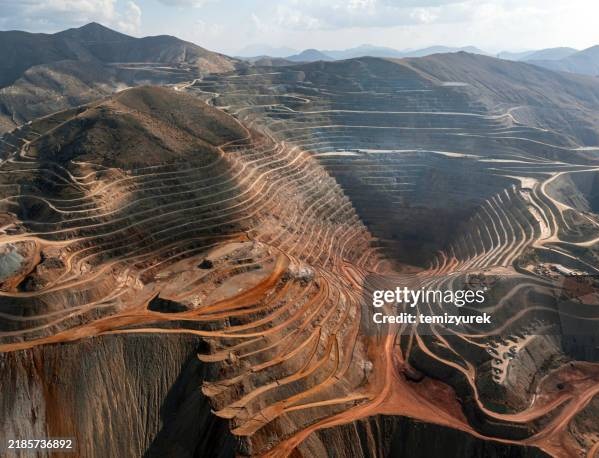
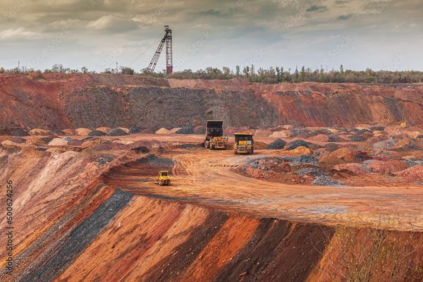
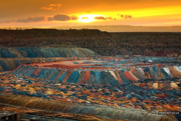
Comment: The idea being proposed is that modern iron ore dumps can be compared to rainbow mountains due to all the bold colours produced. This logic suggests that rainbow mountains are the product of ancient and giant conveyer belt waste heaps (in close quarters) that have been subject to rainwater and time. Well, Roger Spurr states that the spectacular colours are created when a mudfossil is petrified in blood and the transition metals are able to take on and give away the right partners to create the best stabilisation. With these colours, the best clue is IRON which is a component of blood. Anyway, as you see, the heaps produced by a conveyer belt produce uniform sized piles, but that is not what we see in the Peru example given above. Instead there are very thin and wide sized bands and the colours are not regular. For example the ochre/yellow is seen bordering a turquoise band. Also, there is not hint of instability, either physical or chemical. The process called neucleophilic substitution gives a real scientific explanation and explains what can be seen in rainbow mountains found around the world.
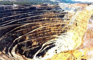
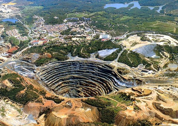
Krivoy Rog ( Kryvyi Rih) mining, Ukraine.
Click image for link
Krivoy Rog ( Kryvyi Rih) mining, Ukraine.
Click image for link
According to @Grok, Krivoy Rog ( Kryvyi Rih) is one of the world’s largest iron ore deposits which are primarily banded iron formations (BIFs). They consist of alternating layers of iron-rich minerals (like magnetite or hematite) and silica-rich chert or quartzite. These formations are geologically distinct, with visible banding that can appear as stripes when exposed. Therefore it seems likely that, when roads are cut through BIFs, the exposed rock faces can display layered patterns of red, brown, black, or gray, depending on the mineral content. Please note: the banding seen at Krivoy Rog is the same as the banding seen from a distance in the Hornocal Mountains, Argentina. @Grok Link
Krivoy Rog mining, Ukraine.
Click image for link
Aerial view of the ore dumps in an open iron ore quarry. Multicolored heaps of ore.
Left image Link & Right image Link.
More Getty images
Link.
Below: Iron ore mining stock photos, believed to be at Krivoy Rog.
|
|
|
Mudfossil chemistry explained ..
YouTube, 24 Nov 2016
Comment: From the transcript; 7:47 “...and the reason that these take on these spectacular colors is because they are able to bond with exactly the partner that they want because it is I believe it’s called nucleophilic reactions. They can grab one guy and say well you’re not really working out for me I want to get to this yellow color and it eventually get to that yellow color cuz it’ll find some body in that blood because the blood has everything.”
|
Click image for video link
|
San Juan River, Goosenecks State Park, Utah, USA
Click image for link
Comment: I have no idea why this is considered evidence of ancient mining, as the result does not seem to be an efficient way to go about mining.
Skazka Canyon. Kyrgyzstan
Click image for link
Beautiful landscapes of remote places. Skazka Canyon, Kyrgyzstan. [35 Photos]
Author Today
The Issyk-Kul region is famous not only for its amazing virgin nature, which can give odds to the "Seven Wonders of the World". In this rich territory there are places, once you find yourself in which, it is hard to believe that this is planet Earth.
Comment: I think this is a prime example of the need to look at what else is going on in the region before a conclusion can be made.
Miscellaneous Mysteries
In reality, the following unusual or strange geology are just the leftovers from many other examples where I’ve been able to use the Mudfossil Hypothesis to de-code. Still, I confess here that I may only partially understand what is going on. Moreover, this section could be far bigger, but I have to draw the line somewhere. However, if I do come across an absolutely amazing and puzzling geological wonder, then I will update.
Stone Forests Or Tripe?
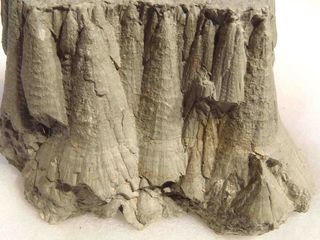
“Tripe” is a standard English word referring to the stomach lining of animals, typically cows, sheep, or pigs, used as food. Sometimes it is used in a dismissive manner like “that’s a load of tripe” (meaning nonsense). The primary meaning, however, is the edible stomach lining. @ Grok Link . Anyway, there are claims that stone forests seen around the world are the remains of titan stomach linings. Whatever, the following examples of these pointy 45-300 metre tall stone rocks are still considered an enigma.
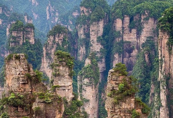
China’s Floating Mountains. Zhangjiajie National Forest Park, located in Hunan Province
Click image for video link
Zhangjiajie National Forest Park, located in Hunan Province, China, is famous for its towering sandstone pillars that inspired the floating mountains of James Cameron’s Avatar.
Part of the Wulingyuan Scenic Area (a UNESCO World Heritage Site), this landscape features over 3,000 quartzite sandstone peaks, rising dramatically from lush valleys. [...]
Comment: There is a long write-up, with more photos and a video here. So I am wondering about these Avatar floating pillars. These towering pillars are also up to 300 metres high....
|
China have built the largest outdoor elevator in the world. 🇨🇳🌏
Welcome to Zhangjiajie National Park, China. The real inspiration for Avatar’s Pandora. 🏔️ | XTwitter video Link
Comment: The 2nd tourism video here is absolutely fantastic!
Zhangjiajie, Hunan. Another great tourism video | Xtwitter video
Link
Zhangjiajie, Hunan.
Link
Comment: Initial pillar close-up video with little vegetation.
For more info @Grok Link
Comment: I am not convinced....
|
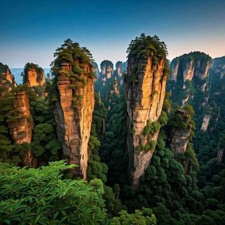
Zhangjiajie National Forest Park, China
Click image for link
Pillar-like mountains that inspired Avatar’s floating peaks, misty, otherworldly, and full of wonder.
|
Lena Pillars (Yakutia, Russia).
Click image for link
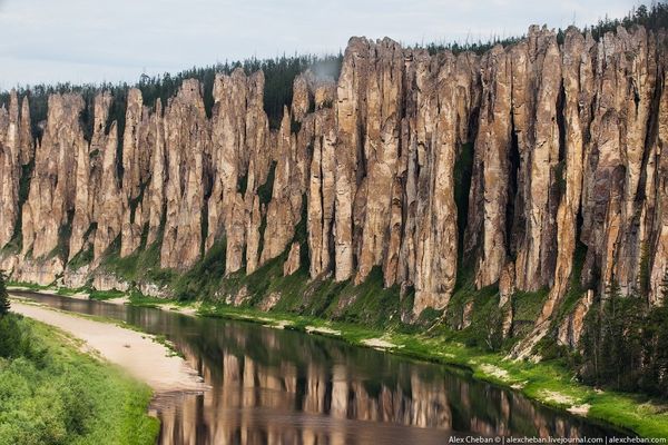
Lena Pillars (Yakutia, Russia).
Click image for link
Lena’s Pillars, also called Lena’s Stone Forest, is a natural rock formation about 60 km upriver from Yakutsk, in Russia. The amazing stone structures towers over 100–200 meters, in height and extends along the river for 40km.
Comment: The information provided by GeologyIn may not be not accurate. According to UNESCO (2012) the pillars form a discontinuous belt that extends back from the river’s edge along the incised valley sides of some rivers in a zone about 150m wide Link . Along the banks of the River Lena the pillars are ~ 100m in height. Overall they are up to ~200m in height. The GeologyIn link provides 8 images. Update: This YouTube video has contradictory info too.... Best of Lena Pillars stone forest & Yakutia Yhyakh aerial
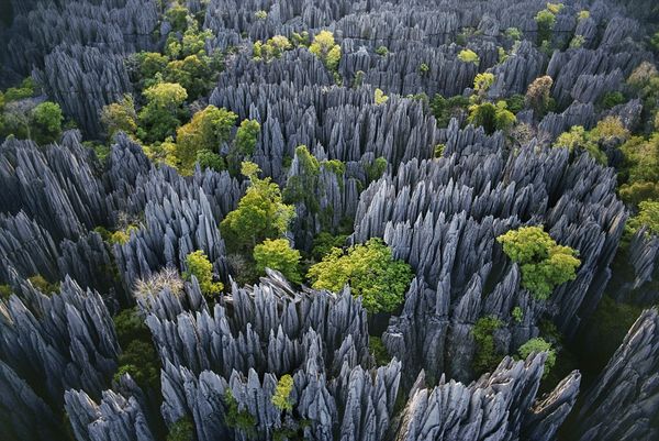
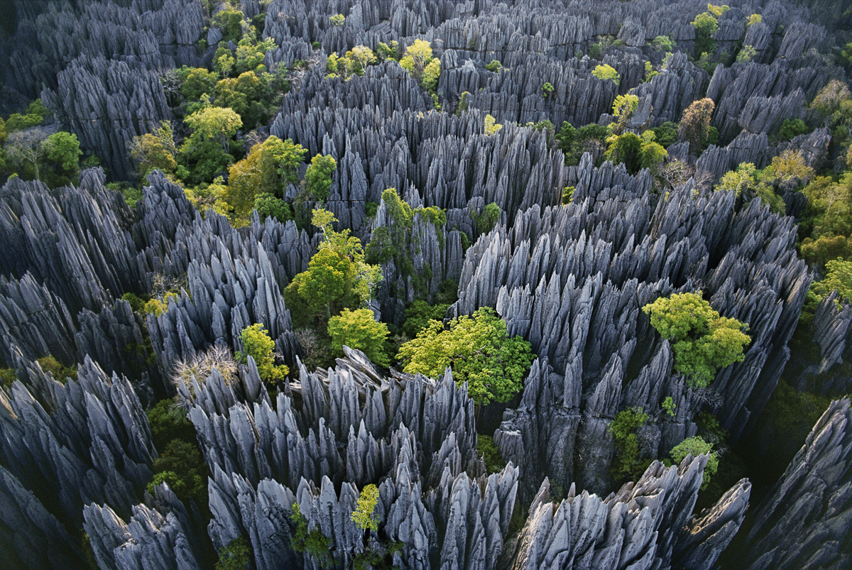
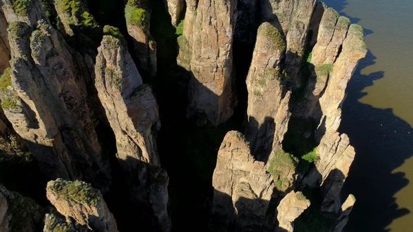
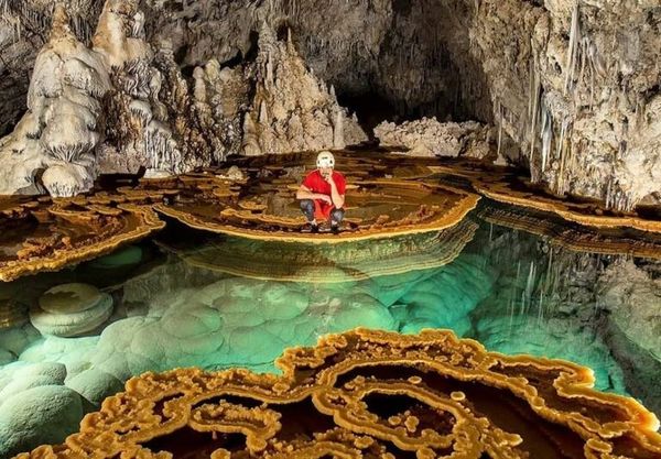
Tsingy de Bemaraha National Park, Madagascar
Click image for link
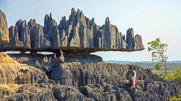
Stone Forests, Tsingy de Bemaraha National Park, Madagascar
Click image for video link (Timestamp)
The Tsingy de Bemaraha National Park is a public park situated in Melaky Region, northwest Madagascar. The public park fixates on two geographical arrangements: the Great Tsingy and the Little Tsingy. Along with the adjoining Tsingy de Bemaraha Strict Nature Reserve, the National Park is a UNESCO World Heritage Site.
Source: link .
Tsingy de Bemaraha is one of Madagascar’s newest parks -- it was opened to the public only in 1998. The 152,000ha Bemaraha is best known for its tsingy -- sharp limestone pinnacles that may reach 150 feet in height.
Comment: Tsingy de Bemaraha National Park is six hundred squares miles and much of it unexplored. At first I thought the above balancing or ‘floating’ rock was fake, but it’s a real feature seen on many photos due to there being an adjacent rope bridge, see more images on Yandex.com Link & National geographic information Link
|

Valle de la Luna, La Paz, Bolivia
Click image for link
Situated just a few kilometers south of La Paz, this location is considered to have a lunar-like landscape boasts stunning clay and sandstone formations.

Coron, Palawan, Philippines
Click image for link

Stone Forest National Park, Yunnan, China
Click image for link
75 miles from Kunming, the Stone Forest, or Shilin, comprises multiple groupings of “stalagmite”-style limestone formations. They’re thought to be more than 270 million years old.

BRYCE CANYON NATIONAL PARK, UTAH
Click image for link
Technically not a canyon, Bryce consists of a series of amphitheaters eroded into the side of the Paunsaugunt Plateau. Filling these spaces are the park’s most distinctive natural features -- hoodoos, pinnacles of colorful eroded sedimentary rock as tall as 200ft.
Click image for link

Natural earth pyramids between Bolzano and Soprabolzano on the slopes of the Ritten in South Tyrol. Italy
Click image for link
Europe’s tallest and most perfectly shaped earth pyramids are to be found on the Renon mountain in several locations: in the gorge of the Finsterbach creek between Longomoso and Monte di Mezzo, in the Katzenbach-creek gorge below Soprabolzano, and in the gorge of Gasters in Auna di Sotto. Link

Rock Pinnacles on Glyder Fawr, 3 km from Pont Pen-y-Benglog, Conwy, Wales
Click image link
Jagged Rhyolitic rock pinnacles on the summit of Glyder Fawr in Snowdonia Eryri North Wales looking towards Glyder Fach and Castell y Gwynt. More images can be found at Alamy Link

The Painted (Ochre) Cliffs. Maria Island National Park, Tasmania.
Click image for link
The Painted Cliffs, also known called ochre cliffs are sandstone stained with iron oxide forming an intricate pattern. It is believed that mineral staining has been caused by groundwater rich in iron oxide seeping through the porous sandstone. Ochre is one of a variety of forms of iron oxide which are described as earth-based pigments. These pigments, used by ancient and modern artists, are made of iron oxyhydroxide, which is to say they are natural minerals and compounds composed of varying proportions of iron (Fe3 or Fe2), oxygen (O) and hydrogen (H). More technical information abut ochre can be found @ThoughtCo Ochre - The Oldest Known Natural Pigment in the World
Comment: RS says he thinks the white holes are blood vessels inside either muscles or tendonous material link. I was thinking ochre is the colour of urine. Maybe the holes are associated with the bladder. This is what bladder blood vessels look like in a human link. The caption reads: “Blood vessels. Coloured scanning electron micrograph (SEM) of a resin cast of the blood vessels around a bladder. Gases and nutrients are exchanged between the blood and surrounding tissue through the permeable walls of capillaries, the smallest blood vessels.” I will update when I know more.

Liesegang Rings, Widemouth Bay, Bude, Cornwall, England.
Click image for link
Liesegang rings are periodic bands or patterns of precipitate that form in a gel or fluid medium during a chemical reaction, typically involving diffusion. They occur when two reactants diffuse into each other, leading to alternating regions of precipitation and depletion. The phenomenon is named after German chemist Raphael Liesegang, who studied it in the late 19th century. More information @Grok Link
Comment: Of course, geologists are still debating.... Well, I found a fabulous Russian website with a large collection of these Liesegang Rings. The only problem is the locations are not provided and the webpage cannot be automatically translated into English, see metaisskra.com. Alamy also has good collection, where some details are available when the mouse is allowed to hover over each image, link

The Tessellated Pavement at Bouddi National Park. New South Wales, Australia.
Click image for link
The Tessellated Pavement is quite extensive but panoramic photos often lose the detail. Maybe the actual pavement is biolipd membrane, but note the abrupt transition to the left and above is clearly another ochre cliff like scenario going on. There is zoom available at this photo link.

The Tessellated Pavement at Bouddi National Park.
New South Wales, Australia.
Click image for hot link

The Tessellated Pavement, Pirates Bay, Tasman Peninsula In Tasmania, Australia
Click image for hot link
Tasmania Tesselated Formation Decoded
YouTube, 22 Mar 2020
This formation is now understood and supports MFU theories of our past.
Comment: Obviously the tesselated pavement in Tasmania is very different to the one in Bouddi National Park, New South Wales, Australia. So, I can’t disagree with RS’s opinion here that these are muscle sarcomeres, but on a titan scale. (Btw RS likes to claim that aponeurosis tendon is made up the same way as muscle sarcomeres. Well, that’s difficult to argue with because anatomy diagrams often show muscle and tendon as being made up the same way.... However SEM images show tendon as being very stringy). Well, I still need to understand these Liesegang Rings, how they originate and get ther colour. Here is the exact image that RS used, which is at the Forestier Peninsula situated a short distance from Eaglehawk Neck on the shoreline. It is no where near as pristine as the image above at Pirate’s Bay link
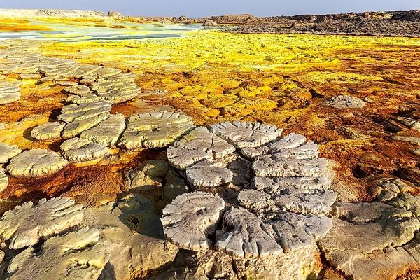
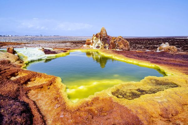
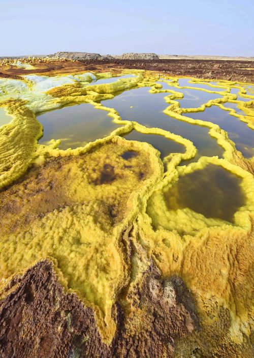
A volcano in the Danakil Desert, Ethiopia
Click image for link
The Deserts Of Africa
World Atlas
7. The Danakil Desert occupies parts of Eritrea, Djibouti, and Ethiopia. The desert that stretches across for about 100,000 square km, is one of the hottest and driest places on Earth. There are several volcanoes and volcanic lakes in the region. The Danakil Desert is nearly completely uninhabited with the exception of a few Afar people who engage in salt mining at the desert.
Comment: This Danakil desert photo is a complete enigma to me. What are the tree stump like patterns about?
The Danakil Desert, Ethiopia
Click image for link
16 Surreal Desert Destinations That Feel Like A Completely Different Planet
Buzzfeed, 10th Apr 2021
3. Danakil Depression — Ethiopia
The Danakil Desert is expansive, hot, and arid, but that’s part of what makes the terrain so surreal. Spanning parts of Ethiopia, Eritrea, and Djibouti, this giant desert stretches over 50,000 miles and includes the iconic Danakil Depression, a destination with temperatures that jump to over 122 degrees Fahrenheit, making it one of the hottest places on Earth. The unique landscape is home to volcanoes, geysers, salt plains, and geothermal springs, which add pops of bright yellows, blues, greens, and oranges to the terrain.
Mud mountain in Hingol national park Balochistan, Pakistan
Click image for hot link
Same image on Pinterest link
Balochistan is the largest province of the Republic of Pakistan, a historical
region and people located at the intersection of Pakistan, Iran, and Afghanistan
map.
Hingol national park Balochistan, Pakistan
Click image for link
Comment: I am wondering if these Hingol national park images are demonstrating the same geological features as below. The only difference is the angle of approx 45 degrees which then allows for different erosion. See more below:
Red Rock Canyon State Park, in Cantile California, USA
Click image for link
Red Rock Canyon State Park features scenic desert cliffs, buttes and spectacular rock formations. The park is located where the southernmost tip of the Sierra Nevada converg…
Comment: RS believes it’s a type of connective tissue, that we could also consider to be like cellulite (see video link below).
Hell’s Half Acre, Wyoming, US
Click image for link
15/19 | Hikearizona.com | Hell’s Half Acre, Wyoming slideshow
Comment: Obviously with the names ‘Hell’s Half Acre’ in Wyoming and ‘Bisti Badlands’ in New Mexico, serious geologists know more than they are allowed to say about what is really going on here.... Whatever, we can surmise that despite the highly eroded geology, both appear to be the petrified remains of titan carcasses.
Strange Rock Formation, Bisti Badlands Valley of Dreams New Mexico USA
Click image for link
Strange Rock Formation in Bisti Badlands Valley of Dreams New Mexico USA
depositphotos.com
Bisti Badlands was formally known as the Bisti or De Na Zin wilderness.
“Bisti” is a Navajo word, meaning “among the adobe formations,” while the word “de na zin” is the Navajo word for the animal.
Comment: Obviously, the Navajo people knew what the deal was here. See link for more images.
|
Hell’s Half Acre, Wyoming, US
Click image for video link (Timestamp)
SEM - Connective Tissue
Click image for link (Timestamp)
Salt Mine Mystery Discussed
YouTube, 8 Oct 2018
Comment: RS is showing a SEM image to compare the microscopic with the macroscopic.
|
The Domes de Fabedougo, Burkina Faso
Click image for link
The Domes de Fabedougou are striking rock formations in Burkina Faso 🇧🇫, known for their unique, dome-shaped structures formed by erosion.
Comment: There are 4 spectacular images here. I don’t understand the erosion/weathering here.
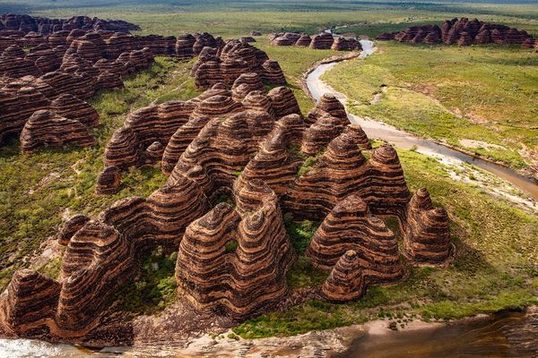
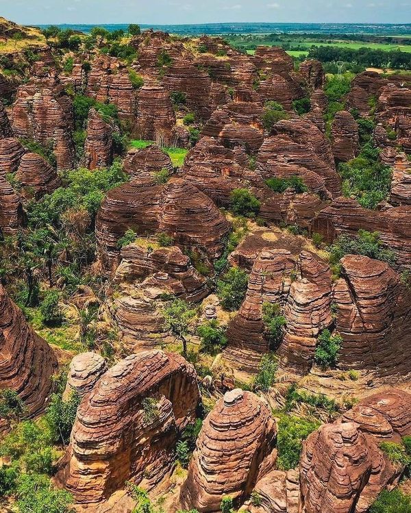
Bungle Bungle Range. Purnululu National Park, Australia
Click image for link
A Photo Trip to the Bungle Bungles [15 Photos]
The Atlantic, 10th Oct 2019
In the Kimberley region of Western Australia sits Purnululu National Park, a protected area of nearly 600,000 acres established as a park in 1987. Purnululu is home to the Bungle Bungle Range, featuring spectacular “beehive dome” karst sandstone formations—some rising more than 600 feet above the surrounding plains.
Comment: Apparently, the official explanation is that the orange and black ring pattern was caused by water and algae creating the dark hues.... I think this explanation is absolutely ridiculous. See YT video 15 UNUSUAL Geological Wonders
A sedimentary “fold”. Lower Ugab River valley of Namibia.
Click image for link
The experts call this a “fold.” We are told ...“this is a stack of originally planar surfaces, such as sedimentary strata, that have been bent or curved during a permanent deformation.” Lower Ugab River valley of Namibia.
Comment: How does that happen? Actually, it reminds me of a very fatty and streaky pork belly joint. RS says it’s connective tissue around bone
https://youtu.be/sZYw_XUVgYc?t=1708
Strange Geology. Anysberg Nature Reserve, South Africa
Click image for link
Comment: I reckon this might be a hand or a foot with a lot of blood surrounding the bone joints. Click image for the hi-res image version.
Kata Tjuta, Northern Territory, Australia
Click image for link
Many people find the soaring ochre-coloured domes of Kata Tjuta more arresting than Uluru, which lies just to the south. Meaning ‘many heads’ in the language of the traditional owners, the Anangu people, these 36 giant monoliths are also known as the Olgas and can be found within the spectacular Uluru-Kata Tjuta National Park. Take the three-hour Valley of Winds Walk around the ancient rocks and gorges, which are sacred to the Anangu people, to get a sense of their majesty.
The “Heads” of Kata-Tjuta, Northern Territory, Australia
Click image for link
The name “Kata Tjuta” was also given to the area by the natives: in their dialect it means “many heads”. A very symbolic name - 36 dome-shaped rocks really do look like someone’s heads.
Devils Marbles, Red Center, Northern Territory, Australia
Click image for link
Comment: Well, this must be a real mystery as we are told they belong to the devil! Besides that, there are a few that have spilt like concretion balls, but mostly they are very irregular in shape. Hence, they don’t seem to fall into the category of concretion balls or tendon balls. Btw, there are 20 pages of images at Alamy Link
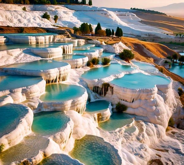
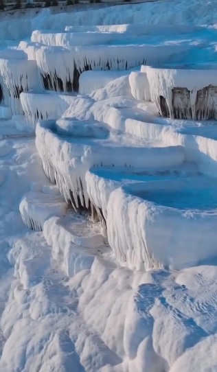
Travertine terraces. Pamukkale, Turkey.
Click image for link
Pamukkale, Turkey, is renowned for its dazzling white travertine terraces, formed by mineral-rich thermal waters cascading down the mountainside. Pamukkale, means “cotton castle” in Turkish. The terraces are made of travertine, a sedimentary rock deposited by mineral water from the hot springs.
Comment: Surely, the terraces were created first and then the thermal springs came afterwards to coat them in carbonate mineral. How can hot mineral springs create these curved terraces?
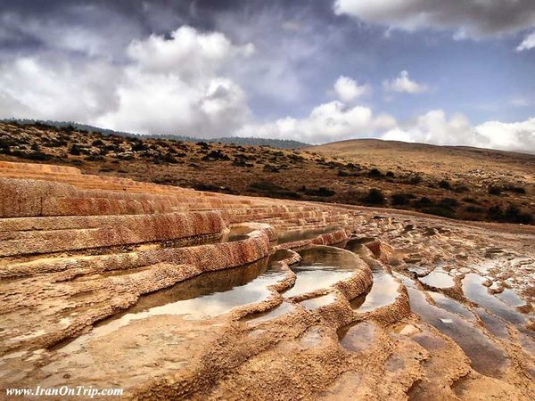
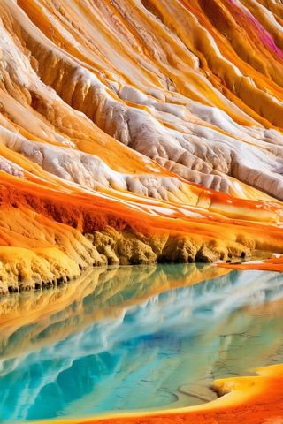
Travertine terraces, Badab Sourt, Iran
Click image for link
Badab Sourt is made of a range of stepped travertine terrace formations thousands of years ago, as flowing water from two hot mineral springs cooled and deposited carbonate minerals on the mountainside. The Badab Sourt Spring is actually comprised of two separate springs with completely different colored and scented water. The first spring contains very salty water that gathers in a small natural pool.During the summers locals swim in the pool and believe its water is useful for curing back aches, rheumatism and skin diseases. The second spring has a sour taste and is predominately orange mainly due to the large iron oxide sediments at its outlet.
Comment: There are 12 photos here.
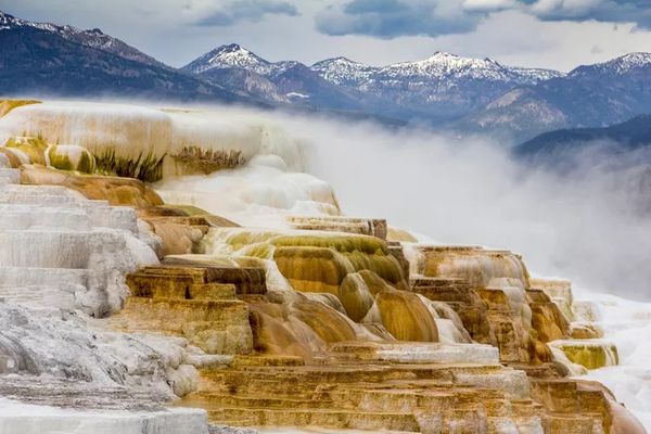
Travertine terraces at Yellowstone National Park, US.
Click image for link
Yellowstone National Park’s Mammoth Hot Springs consist of travertine terraces formed by an abundance of geothermal vents.
8 Magnificent Travertine Terraces Around the World
Treehugger, May 20, 2021
1, Pamukkale (Turkey) 2. Huanglong (China) 3. Semuc Champey (Guatemala)
4. Mammoth Hot Springs (Wyoming) [Yellowstone National Park] 5. Badab-e Surt (Iran)
6. Bagni San Filippo (Italy) 7. Egerszalok (Hungary) 8. Plitvice National Park (Croatia)

Travertine terrace formation. Skocjan Caves, Slovenia
Click image for link
Referred to as the “Underground Grand Canyon,” the Škocjan Caves in Slovenia are considered some of the largest subterranean chambers in the world.
Comment: This image is 8/15 from the slideshow. I was looking forward to how the Smithsonian Magazine would explain the formation of these Travertine terraces, but nothing, except to refer to them as limestone pools.
Travertine terraces. Pamukkale, Turkey.
Click image for video link
Pamukkale, meaning "cotton castle" in Turkish, is home to 17 stunning tiered pools that are among the most beautiful natural hot springs in the world. The cascading white travertine terraces, a type of limestone, offer breathtaking views over the city of Denizli. The serene 94-degree Fahrenheit waters mirror the vibrant blue of the Aegean sky, creating a picturesque scene.
Drone footage overview video Link
|
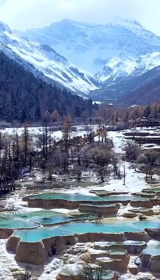
Huanglong (Yellow Dragon) Travertine Terraces, China
Click image for video link
In the southern part of the Minshan Mountains in China, at an altitude of about 3.4 km above sea level, there is a place with an extraordinary landscape consisting of rapids, small waterfalls, lakes and caves.
The Huanglong (Yellow Dragon) Travertine Terraces stretch along the hillside for 3.5 kilometres. The broken pools owe their existence to limestone dissolved in water.
|
Click image for video link
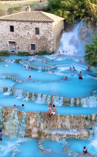
Saturnia Hot Springs and Saturnia Mill, Tuscany
Natural thermal waterfalls cascading over travertine terraces, with water at a constant natural temperature of 99.5°F
|
Yellowstone National Park’s Mammoth Hot Springs
Click image for link
Comment: Please note there are no terraces at this specific location! Slideshow:
Mammoth Hot Spring in Yellowstone National Park [35 Photos]
|
Click image for link
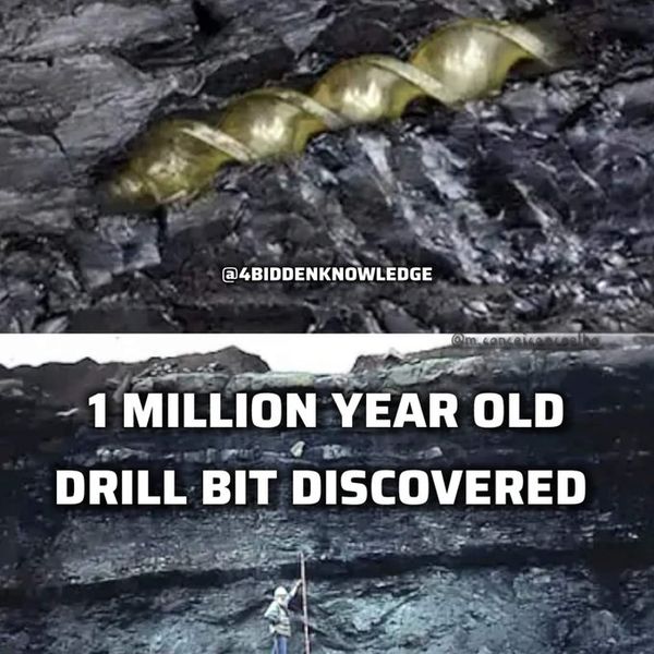
This artifact, an iron tool, was discovered within a coal seam ensconced in a layer of clay over two meters thick, presenting a conundrum to the scientific community about its origin and age. John Buchanan reported his find to the Scottish Society of Antiquaries on Dec 13th, 1852, where it was examined and debated extensively. The proposed age is over 1 million yrs based on the age of the coal it was embedded in. Billy Carson
Comment: There are whole books written about geological anomalies like this.
Drill Bit Found in Coal Suggests Advanced Civilization LONG Before Humans Thought to Walk Earth?
The Epoch Times, 15th Jan 2023
Oopart (out of place artifact) is a term applied to dozens of prehistoric objects found in various places around the world that seem to show a level of technological advancement incongruous with the times in which they were made.
According to the conventional view of history, humans have only walked the Earth in our present form for some 200,000 years, with our ancestors’ history extending back perhaps 6 million years. The Earth’s coal is said to have formed hundreds of millions of years ago. That’s why the appearance of a man-made iron instrument resembling a drill bit in the heart of a large chunk of coal puzzled the historians who found it in the 19th century.
It appeared that a man-made tool as advanced as the tools used in the 19th century was deposited in the organic matter that formed the coal before it became coal. Was a civilization advanced enough to use drill bits present hundreds of millions of years ago as this coal was forming? [...]
In summary, Buchanan said that the iron instrument was found within a seam of coal about 22 inches thick, which was in turn buried in a bed of diluvium or clay mixed with boulders some 7 feet thick.
Discovery of an iron instrument lately found imbedded in a natural seam of coal in the neighbourhood of Glasgow (PDF)
Proceedings of the Society of Antiquaries of Scotland, 1885
Click image for link
Why is Coal found in "Veins" and Seams like Membranes and why does Clay mix in and why so much Iron?
YouTube, 27 Aug 2024
Summary | Coal seams were once vein blood at a certain state of oxygenation (depleted of oxygen black magnetite blood) which eventually hardens up and turns to coal.
Comment: I don’t think this video is for beginners. RS gives the official explanation for coal and then gives his opinion. The information about lungs is very confusing. Whatever, RS shows a coal vein with breaks and then he compares that actual biological veins. What is interesting is how biological the coal mine looks. Lot of red and yellow and features that look like stalactites hanging down from the ceilings. Not what is typically shown inside a coal mine.
Top: Strange seashell looking structures found on a mountain top
Bottom: Cone in Cone Structures
|
Click image for video (timestamp) link
Comment 2: RS says the rock is a lung. Blood carrying oxygen in tubes is converted by these adjacent seashells that act as transactors of energy and could be considered like chakras, hence the shape. So could these ‘seashells’ be compared to cone-in cone structures? See below for more information.
Cone in Cone Structures Elk Creek, Girard Township, Erie County, Pennsylvania, USA
Click image for link
Cone in Cone Structures a Geologic Mystery
Mindat.org, Oct 15, 2011
Let me start this article by first stating, as a matter of fact, “Cone in Cone Structures” are not minerals. They are composed of minerals, which would place them in the category of “rock”. These structures are far more than just mere rocks however. [...]
First, these structures are not really known about. Someone finding one would most assuredly assume their find to be a fossil. The structures very closely resemble fossils. Most likely the only people who would know anything about these structures would be researchers. The structures are rock and most rock-collectors are not really rock-collectors but instead mineral-collectors.
Comment: There is a long article with more photos.
|

Stunning aragonite “Flowers” in a cave on Mallorca island, Spain.
Click image for link
Comment: Stunning... More chakras?
Lechuguilla Cave, New Mexico, US
Click image for link
Thought to be the deepest cave in the US, home to amazing mineral formations, and has been studied by explorers since the 1980s.
Comment: I have no idea what is going on here, but it's amazing!
|